Closing 18th February 2022 - Public Meeting 5:30 Monday 14th February opposite 37 Rapid Creek Road
This is a very concerning application that will change the amenity of Rapid Creek Road and create an unacceptable precedent in the northern suburbs.
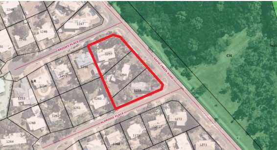
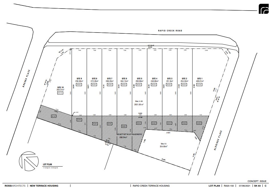
Tropics Consultancy Group has applied to the Minister for Infrastructure, Planning and Logistics for an Exceptional Development Permit (EDP) for the purpose of a subdivision and consolidation to create 11 lots (with 7 lots less than 300m2) and a building envelope plan on Lots 1257, 1258 and 1259 (1 Brooks Place, 37 Rapid Creek Road and 14 Aldridge Place, Milner) Town of Nightcliff.
110853514_21085_-_The_Terraces_CIVIL_and_ENG_TCG.pdf
110853569_The_Terraces_Proposed_Statutory_Covenant_TCG.pdf
110853572_The_Terraces_Design_Guidelines_TCG.pdf
110853598_RA20-150_-_The_Terraces_-_EDP_Plans_TCG.pdf
110889468_TCG_Lot_1257__1258_and_1259_EPD.pdf
Posted in Community Alert
Sue of Fannie Bay asks who made the decision to close the Parap Pool for maintenance in the middle of the school holidays and the hottest time of the year?
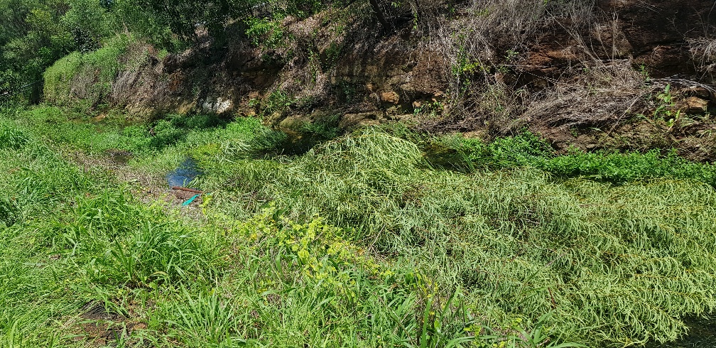
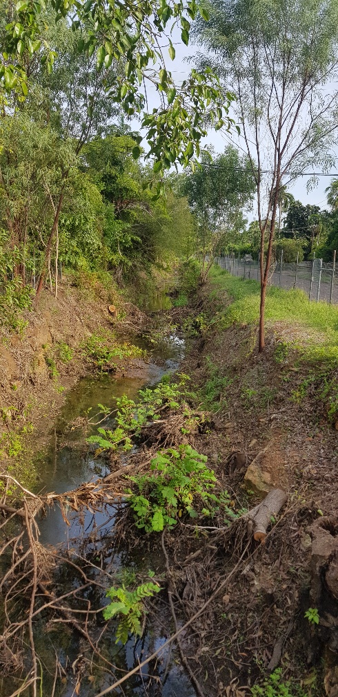
The answer is the City of Darwin (COD) and as a resident next to the Playford street Racecourse Creek / Drain I can report on my totally unsatisfactory recent experiences with the City of Darwin.
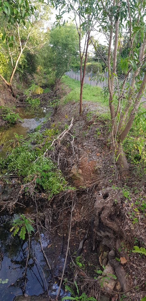
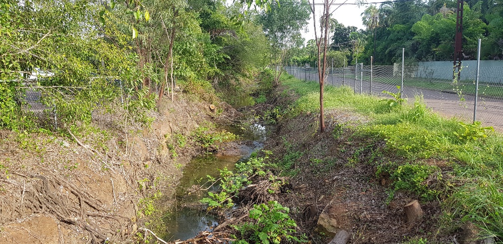
There is a perfectly functioning creek (now classified as a drain by the COD) that runs between Playford Street and the Darwin Turf Club. It provides a habitat for frogs, birds and wildlife. It has not been maintained by the COD for many years and during that time it has effectively managed stormwater dispersal, including during Cyclone Marcus.
In 2014 the former Lord Mayor and officials visited my home after some large trees were cut down by the COD under the excuse of “tree roots create mosquito breeding sites in the drain/creek”, so the trees have to go. The former Lord Mayor said future trees and native grass would be encouraged to grow in the area and trees won’t be felled again.
However, on 7 December 2021, COD contractors turn up and start chain-sawing down trees in the creek/drain area and using a crane to lift them out. The COD advised this was to remove coffee bush – but no coffee bush was being cut – just trees, on the banks, floor and tops of the drain / creek.
 So, undertakings given by the former Lord Mayor and staff to ratepayers are just ignored by the current Lord Mayor and staff - how unimpressive.
COD stopped work after my complaint and sent out a flyer on 14 th December to neighbours and residents briefly explaining the intended works are to enable the creek drain to perform at its design capacity and then recommenced tree cutting and chipping with assurances from the COD that trees on the top and sides of the bank will be left to minimize visual impacts and provide erosion control.
Then on 4th and 5th January, an unsupervised contractor walked up the creek/drain with a chainsaw and cut down many Acacia trees on the sides and top of the creek/drain. The COD response to this broken undertaking were to call these trees “weeds”. See pictures of felled trees.
 And as a major stakeholder in the area and next to the Playford street drain/ creek, presumably the Darwin Turf Club were not consulted by COD prior to starting these tree felling works which has removed the treed buffer zone between the DTC facilities and the neighbours.
Then COD advised on 7th January, that once all the tree felling and clearing is complete, that the bottom of the creek/drain will be dredged. This fact was conveniently omitted from the COD notice to residents on 14 December 2021.
I wonder what the next instalment will be in this horror movie that shows the COD greening our city policy in action?
 Meanwhile contractors are busy cutting trees, lifting them out with a crane and chipping them at a cost of $1000s per day. Yes, this is your rates at work. At the same time, COD has the tree seedling give aways and major landscaping programs to encourage a greener city and more flora and fauna – while at the same time destroying trees and habitat adjacent to Playford Street.
No COD Alderman, Lord Mayor or official has come to inspect these works and or discuss them with residents adjacent to these activities. The COD attempts to justify the works by saying they need to re-instate the creek/drain to its full capacity, presumably to protect houses from flood damage. But despite Cyclone Marcus and other big rain events, houses have not flooded. Sure, minor flooding of local roads can occur under huge rainfall events, but when the tide goes out, so does the flood water in the creek/ drain. It really is that simple.
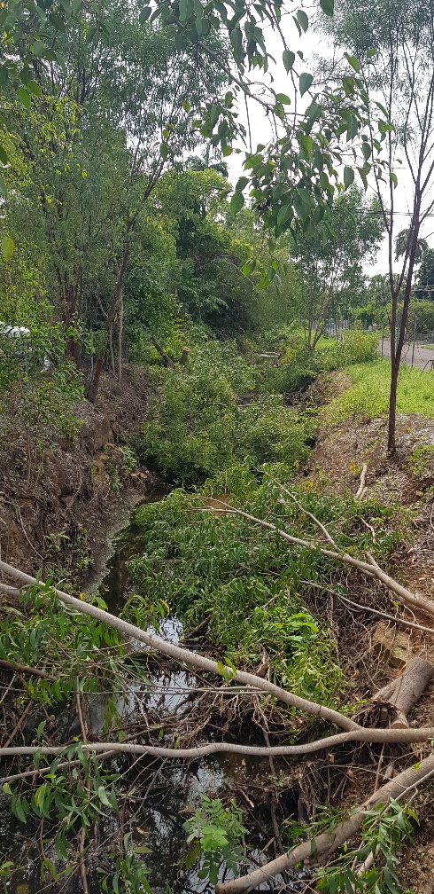 COD are wasting ratepayers’ money on a make work project and removing habitat and also removing the visual screen between the neighbours and the Darwin Turf Club Grandstand, carpark and Stalls area. So much tree debris from one tree cutting exercise was left in the drain / creek that it recently washed down to Buntine Avenue, which is the entrance to the DTC from Dick Ward drive, and it acted as a beaver type dam, totally blocking the 2 large pipes there. This caused the road to flood and the water nearly went into Silks.
Hence claims by the COD re their expert technical monitoring and supervision of this project are just nonsense.
And where is the COD Erosion Control and Sediment Plan to prevent sediment moving off site and to prevent erosion on the banks now that the trees have gone? Where are the NT EPA in this matter, who approved these works, the COD itself it seems and why are these works not shown on the COD projects web site? Where are the hydrology studies used to justify these works and where was the public environmental approval process for these works? Or is the COD now above the law and it doesn’t care about sediment moving offsite, its greening policy and impact upon neighbours?
 If the City of Darwin were sensible, they would stop wasting money, stop destroying habitat and the stability of the creek/ drain and work with the residents and the Darwin Turf Club to re-instate the trees and shrubs that have been unnecessarily removed. The residents are not against weed removal and tree removal in the base of the creek for stormwater flow.
But my guess is that the COD will keep doing what they are doing and wasting your rates as it appears to be someone’s pet project.
This work is NOT in the interests of ratepayers and should be stopped.
Geoff Farnell
Posted in Community Alert
From the desk of Planning Reform Team, Department of Infrastructure, Planning and Logistics
This closes Midnight Friday, 4 March 2022
Here are the attachments:
images/documents/NTG/111907261_Detailed_Information_Paper.pdf
images/documents/NTG/111907263_Integrated_Schedule_of_Amendments.pdf
images/documents/NTG/111907277_Summary_Paper.pdf
images/documents/NTG/111907280_Appendix_C_-_Supplementary_Information.pdf
111907283_Appendix_B_-_Individual_Project_Amendments_-_Designing_Better.pdf
111907285_Appendix_A_-_Individual_Project_Amendments_-_Economic_Recovery_Actions.pdf
Here is an extract which appears to be concerning:
Establishing a Permitted Use Department of Infrastructure, Planning and Logistics Page 1 of 3
A permitted use under the NT Planning Scheme 2020 may not require a development permit.
However, if property is within a building control area, building certification may be required.
You don’t need a development permit for a permitted use if the development:
• meets all planning requirements, and
• does not require consent because of an overlay
Dear Stakeholder
We are excited to share with you that a planning scheme amendment for Planning Reform Phase 2 Stage 1 is now live and on public exhibition until midnight, Friday 4 March 2022.
The Minister for Infrastructure, Planning and Logistics has decided to consolidate 2 projects to form this amendment:
- Economic Recovery Actions project – the NT Planning Scheme 2020’s response to the recommendations of the Territory Economic Reconstruction Commission; and
- Designing Better project – the NT Planning Commission’s review of apartment and mixed use building design.
Both projects seek to improve processes and outcomes relating to the design of buildings and place.
You can view the documents and make a submission through Planning Notices Online.
We encourage you to read the Detailed Information Paper and associated documents, and make an appointment to speak with the Project Team about any clarifications, concerns or compliments. The Project Team will be exclusively available for booked appointments between Thursday 4 February and Friday 18 February 2022 across Darwin, Palmerston, Katherine and Alice Springs.
To book an appointment please visit haveyoursay.nt.gov.au.
If you have any questions about the proposal in the meantime, please feel free to contact the Project Team on (08) 8999 8963 or via This email address is being protected from spambots. You need JavaScript enabled to view it..
Thank you for your ongoing interest in Planning Reform and/or Designing Better, and we hope to talk with you soon to receive your feedback.
Kind regards,
Planning Reform Team
Posted in Community Alert
Infrastructure NT Commissioner Appointed
26 January 2022
The Territory Government has appointed Ms Louise McCormick to the role of Commissioner for Infrastructure NT.
Over the past 16 years Louise has worked in the Northern Territory, she has been involved in planning, delivery and management of some of the Territory’s largest and most complex infrastructure projects and has been instrumental in securing Australian Government funding for a significant road upgrades across the Northern Territory.
We have established the Territory Investment and Major Project Commissioners to actively pursue investment and drive major projects in the Territory. The Infrastructure NT Commissioner will ensure we build the public infrastructure needed to deliver those important job-creating projects, providing a crucial link to achieving the NT Government’s goal of a $40 billion economy by 2030.
The immediate work the Infrastructure Commissioner will undertake is:
- Build on infrastructure work that Government has already done, and have a strategic approach to creating jobs and planning for the future.
- Work in conjunction with the Major Project Commissioner to win projects and make them happen.
- Establish a strategically focussed professional team that will represent the Northern Territory in national discussions to ensure our public infrastructure requirements have Commonwealth and broader community support, including submissions to Infrastructure Australia for priority project listing;
- Develop a new Territory Infrastructure Strategy incorporating agency Strategic Infrastructure Plans, to get the right infrastructure built at the right time, in the right place to support productivity, economic growth and regional sustainability;
- Oversee business cases and concept plans for ‘shovel worthy’ government projects underpinned by appropriate community engagement and planning through the regional recovery committees.
- Review and define processes to assess and prioritise all major publicly funded infrastructure investment proposals.
Infrastructure NT will establish strong relationships at the national level with the relevant Australian Government agencies and other jurisdictions to ensure that the Territory is front and centre as Australia’s comeback capital.
Quotes from the Minister for Infrastructure, Planning and Logistics, Eva Lawler:
“Quality projects that enable economic development are important to the Northern Territory’s bounce back. We are well positioned to become Australia’s comeback capital.
“Louise McCormick is an asset to the Territory, with over 20 years’ experience in the transport and infrastructure sectors, and I congratulate Louise on her appointment to the role of Commissioner for Infrastructure NT.
“Louise is a multi-award winning Chartered Engineer in both civil and structural engineering, and is well placed to lead the Infrastructure NT Commission to work with the Australian Government and private sector secure and deliver critical infrastructure development in the Territory.
“We are a Government who is doing the work and making sure the Northern Territory is positioned to win projects and investment, which is in the interests of Territorians, jobs, business and our future.”
Quotes from Infrastructure Commissioner, Louise McCormick:
“The Territory is the land of opportunity and infrastructure plays a key role in unlocking those opportunities. Focussing on strategic infrastructure planning and investment will pivot the Territory towards long-term sustainable economic and population growth.
“Working closely with potential investors, industry, the community and my colleagues across both the Northern Territory and Australian Governments will be essential to achieving the best outcomes for the Territory.’
Quotes from Infrastructure Australia CEO, Romilly Madew:
“A long-term advocate for the Territory, Louise has engaged constructively with Infrastructure Australia for several years and was a key member of the Working Group that guided the development of our new Assessment Framework for major infrastructure projects.
“As highlighted in the 2021 Australian Infrastructure Plan, targeted infrastructure investment and reform in the Northern Territory will be absolutely key to developing new industries, enhancing connectivity and liveability and supporting the national economic recovery effort. Louise is exceptionally well-placed to lead Infrastructure NT during this critical time.”
Posted in Blog & Opinion
Hello,
Here is a quick round up of PLan related activities for this week.
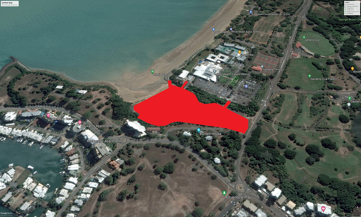
Save Little Mindil
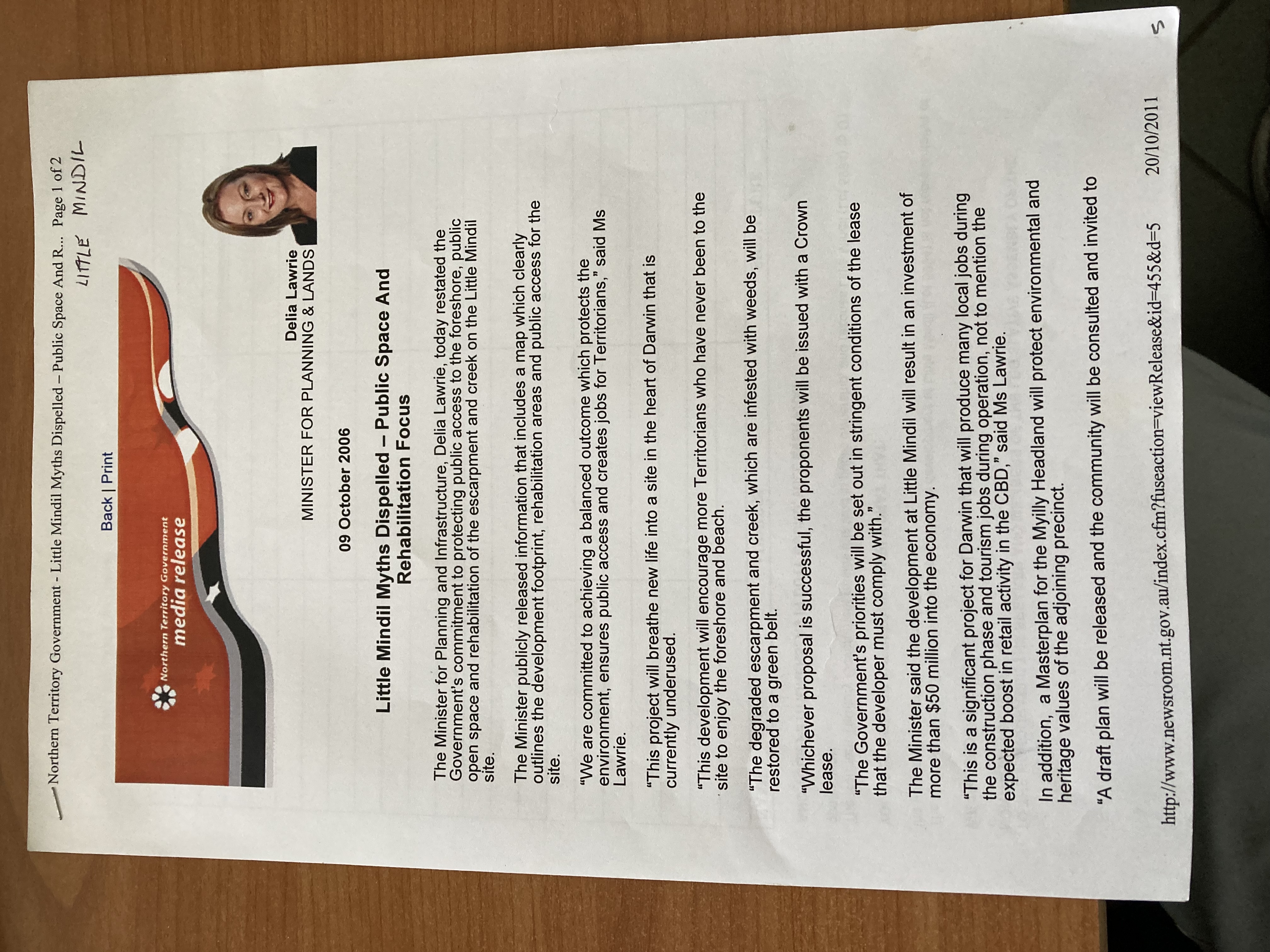
Save Little Mindil NTEPA Submissions close midnight Tuesday 2nd November.
There are just a few days until the NTEPA (Northern Territory Environmental Protection Authority) consultation on the Little Mindil fiasco closes.
It is vital that the NTEPA understands how disenfranchised the community has become in this process. If you submit you are recognised as part of the community.
Your submission should be sent to This email address is being protected from spambots. You need JavaScript enabled to view it. before midnight 2 November 2021.
There are many hundreds of pages of information in the proposed developer’s package. This can be read here: https://ntepa.nt.gov.au/consultation/north-one-hotel-and-apartments
There is a set here also: https://planinc.org.au/news/current-campaigns-2/291-little-mindil-under-threat.html
Here are some key points you may consider for your submission:
• The proponent has failed to provide the community consultation required by NTEPA. Note EP Act Section 43 see the end of this page.
• There is inadequate time in the NTEPA process for the community to respond with any understanding of the project.
• There was a rezone that the public knew nothing about after the NTG was consulted by the applicant.
• There was a covenant over the open space which was removed last year with no notification or consulation to the community.
• Ten years ago, it was declared not possible to put a road from the Gilruth Avenue hill into Little Mindil. That is why we now drive through the casino grounds to get access.
• The ground is heavily polluted with seawater and many years of dumped materials in the ground.
• Noise levels will increase significantly.
• The creek is not depicted on any drawings near the proposed roadworks.
• The escarpment may well be affected by road construction and the undergrounding of the power lines at the escarpment base.
• The development seeks reduced setbacks at the escarpment and Gilruth Avenue.
• There is no public parking to facilitate the guaranteed public access to the foreshore.
• There is inadequate parking for the number of units proposed.
• There is no mention of global warming or the dangers of building in the storm surge zone.
• It is likely that no location in Australia would allow such a development so close to the water line, let alone in a cyclone area.
• The resultant building may not be insurable.
• Who is responsible for remediation to damage to the break walls and how will heavy vehicles get access to the coastline? Is the development placing a burden on the public purse to remediate as has happened in northern beaches Sydney and the Gold Coast amongst other locations? See They’ve Kerbed And Guttered Narrabeen Beach for a recent instance.
• The drawings supplied are not to scale and some drawings contain two scales.
• A1 sized drawings should be available to all interested parties.
• The buidings are three storeys above the height of the escarpment blocking views from the Heritage Precinct.
• The Green belt will be destroyed in the area.
• The buildings will be visible from many locations.
• The buildings do not contribute in anyway to the amenity of the whole area.
• Shared Public access to the whole of the block including public parking was guaranteed by previous government.
Flyers
The Little Mindil Flyers have arrived. Public awareness is critical to saving Little Mindil. Please write back if you can do your street or more.
Also, we need to get the flyers into all the coffee shops, restaurants and notice boards in the CBD and suburbs.
We can drop the flyers off to your address in lots of 100 or more.
Welcome back Shorebirds
Birdlife Top End, Save Lee Point and PLan
Sunday November 7th, 4.30pm - 6.30pm, Lee Point Beach
Come down to Lee Point Beach to welcome the shorebirds back to the beaches of North Australia.
This event will give you an opportunity to view the amazing birds that have journeyed thousands of kilometers to be feed and roost on our beaches.
There will be free food and activities for kids.
All are welcome, not just the shorebirds!
Welcome Back Shorebirds Flyer
Mitchell Park Botanical Gardens/Nature Park initiative
An effort to make the suburb of Mitchell and the neighbouring part of Litchfield Shire into a nature park/botanical gardens has commenced.
Meetings
Just a quick reminder that the first of the regular get together meetings will be at the Palmerston Library on the 2nd and 4th Wednesdays of each month at this venue. Please pass the word around.
Hope to see you there.
Kindest regards,
Jim Young
0439 776 025
For more information see here: https://planinc.org.au/news/mitchell-park.html
Memberships
The 2022 Memberships are open, pay today and become a member until Christmas 2022. As a volunteer organization we rely on the community to assist us in our efforts. Please see here: Membership and Donations
PLan collaborates with resident and community groups on matters including the built environment, heritage, cultural and environmental values of concern in the Northern Territory and Australia. PLan’s aim is to achieve, for the community, sustainability in terms of social, cultural, environmental and balanced long term economic impacts.
Environmental Protection Act 2019. Section 43.
'43 General duty of proponents
A proponent of an action has the following general duties under an environmental impact assessment process:
(a) to provide communities that may be affected by a proposed action with information and opportunities for consultation to assist each community's understanding of the proposed action and its potential impacts and benefits;
(b) to consult with affected communities, including Aboriginal communities, in a culturally appropriate manner;
(c) to seek and document community knowledge and understanding (including scientific and traditional knowledge and understanding) of the natural and cultural values of areas that may be impacted by the proposed action;
(d) to address Aboriginal values and the rights and interests of Aboriginal communities in relation to areas that may be impacted by the proposed action;
(e) to consider the principles of ecologically sustainable development in the design of the proposed action;
(f) to apply the environmental decision-making hierarchy in the design of the proposed action;
(g) to consider the waste management hierarchy in the design of the proposed action.’
Regards,
Nick Kirlew
Convener PLan: the Planning Action Network Inc
0447 499 794
Email: This email address is being protected from spambots. You need JavaScript enabled to view it.
Web: https://www.planinc.org.au
Posted in Blog & Opinion
In response to the recent commentary by Catriona Tatam who is the chief executive of the Urban Development Institute of Australia NT.
The City of Darwin is to be congratulated for stepping up to bring awareness of a serious failure of the planning process to bring the community along with the development of Darwin.
As far as PLan can establish only 15 members of the public were aware that the 2015 "consultation" occurred. PLan spent three years trying to get Defence Housing Australia (DHA) to come to Darwin to discuss the project. Eventually a "suit" arrived and said they had no intention of discussing the development with community. I was at that meeting.
There is no area plan for Lee Point. There is a DHA drawn area plan for the development. This was accepted by Dave Tollner. NT government have never done a comprehensive area plan for Lee Point.
Catriona Tatam does highlight that “public consultation” is now a failed process. Witness the recent turning away of nearby residents from the Little Mindil community consultation process by that developer.
How sad to read the statement that the retention of bushland should be balanced against the need for new land for development. Did Berrimah farm change hands for a $1 or is that just a myth? How many homes can go onto that cleared land? Those homes would be along established transport and infrastructure. Travel times to defence facilities would be greatly reduced when compared to a potential suburb at Lee Point.
Lyons and Muirhead are the hottest places in Darwin. Lee Point was the coolest place in Darwin. Clear fell to lay bitumen is just out of date for the tropics, note the thousands of trees that are going into the city and surrounds now. Catriona Tatam seems to forget the 12,000 shorebirds and Casuarina Coastal Reserve which are placed at significant risk by this misadventure.
The plans for Lee Point have a tourist precinct with 8 story buildings. Are we to be grateful that this stage seems to have fallen off the table? The block sizes proposed for this development are clearly not suitable for tropical design.
As to the City of Darwin exercising it’s right to communicate with the government of the day over any issue it deems fit, I would have thought the Property Council would support the domcratic process. The City of Darwin will eventually be responsible for the resultant suburb.
Nick Kirlew
Convener PLan the Planning Action Network Inc
This email address is being protected from spambots. You need JavaScript enabled to view it.
Posted in Blog & Opinion
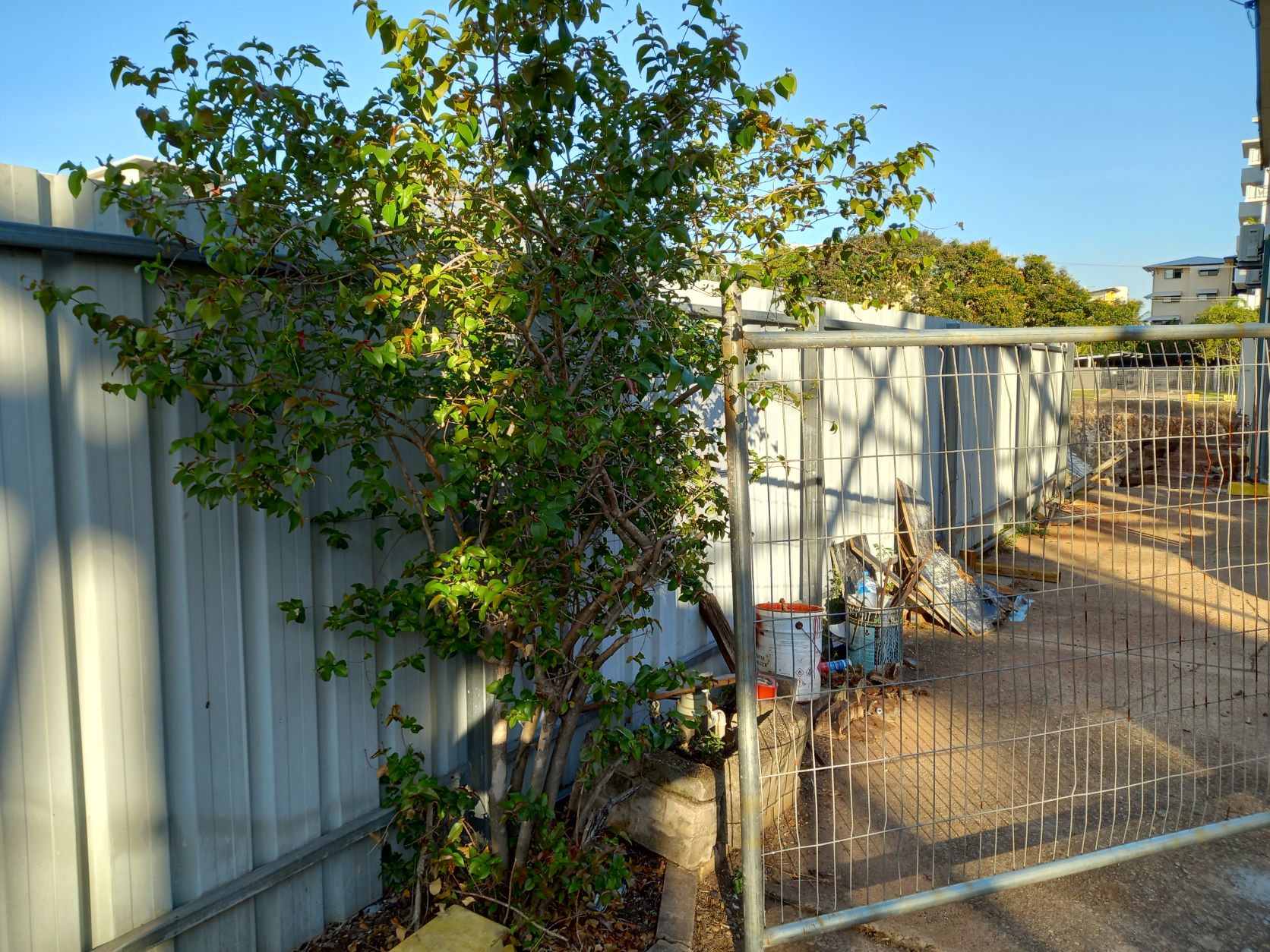
I live adjacent to a large "dead" site known as the Asti Motel.
There is a new development proposal see here: https://planinc.org.au/news/current-campaigns-2/309-old-asti-site.html
Some seven and a half years ago the site stalled, and Larrakeyah has been living with temporary fencing on three street fronts and a massive pit in the ground that holds water year-round.
In the latter years due to the building next door threatening to slide into the pit the owners have been backfilling the pit, we now have two deep pits with sheer walls that hold water year-round.
Late September 2021 builders turned up and began to excavate away the footings of the building that is falling into the pit.
No notice to nearby residents, no notification of who is doing the works and no secure gate.
All these pictures of gates are taken after 5pm when the site has been abandoned for the day.
 |
| This picture I took on the first night mid September. Rang NT Worksafe who I later learnt decided to take no action. The staff who work after 4:21pm do not have access to an email address photos can be sent to. The process is for the resident to send a sms to the NT Worksafe staff member’s personal phone. My SMS failed so no action. |
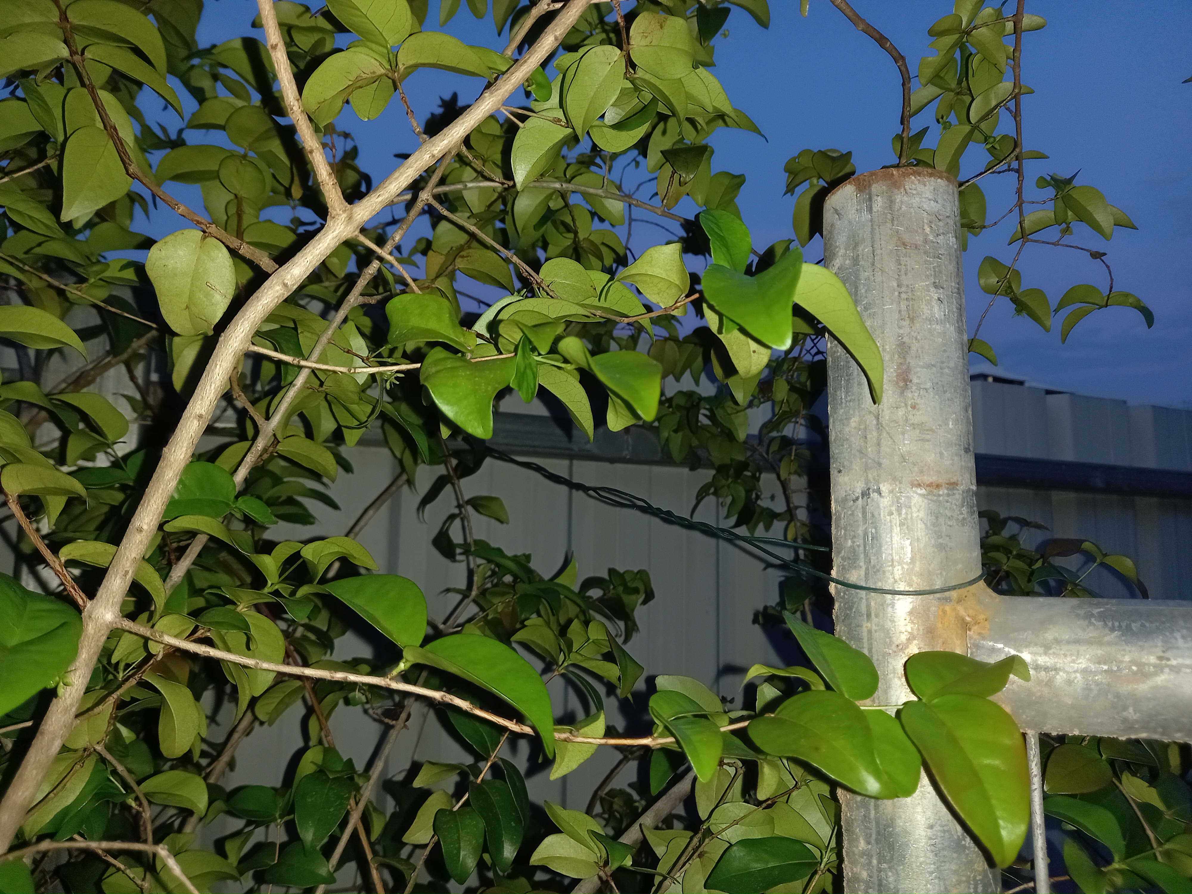 |
| After the weekend I contacted NT Worksafe again, and action occurred, signs went up identifying the builder and the gate was secured by some twist tie: |
So again, I notified NT Worksafe advising that the twist tie will slip over the top of the gate. Next day a chain and padlock appear.
 |
|
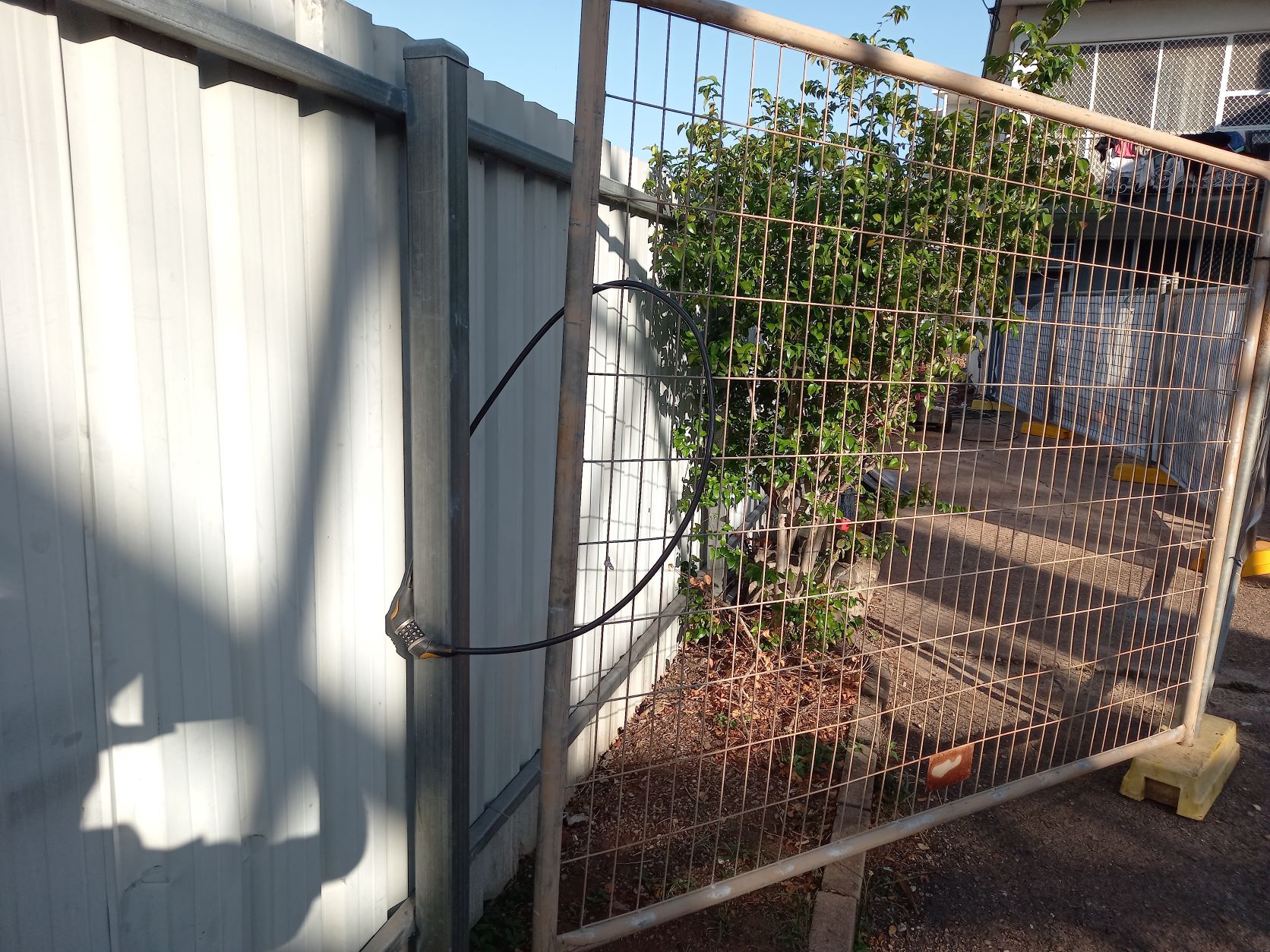
A week later the chain and padlock are replaced with a bicycle lock.
Slide the bike lock up the fence will come away from the post. I contacted NT Worksafe and the next day the bicycle lock was doubled over creating a tighter join.
|
 |
| This most recent photo is taken from inside the site at 5:20pm. Different gate, same effect, no one is watching these cowboy’s and our children are at risk. |
Again I have rung NT Worksafe. So, four calls in two weeks, perhaps not good enough?
Posted in Community Alert
Sign the petition here: https://actionnetwork.org/petitions/save-little-mindil
Read the application here: Little Mindil Under Threat!
Down load the current handout for your street: Current Handout
You can donate to the campaign here:
Posted in Current Campaigns
This Sunday 26th September at 5:30 pm meet at Little Mindil (25 Gilruth Avenue) with like minded community members.
Bring a chair and picnic to stay on for a spectacular sunset.
See the full submission here: https://planinc.org.au/news/current-campaigns-2/291-little-mindil-under-threat.html
Sign the petition here: https://actionnetwork.org/petitions/save-little-mindil
If you can assist our volunteer organisation to meet costs please donate here:
https://planinc.org.au/about-us/membership.html
Posted in Current Campaigns
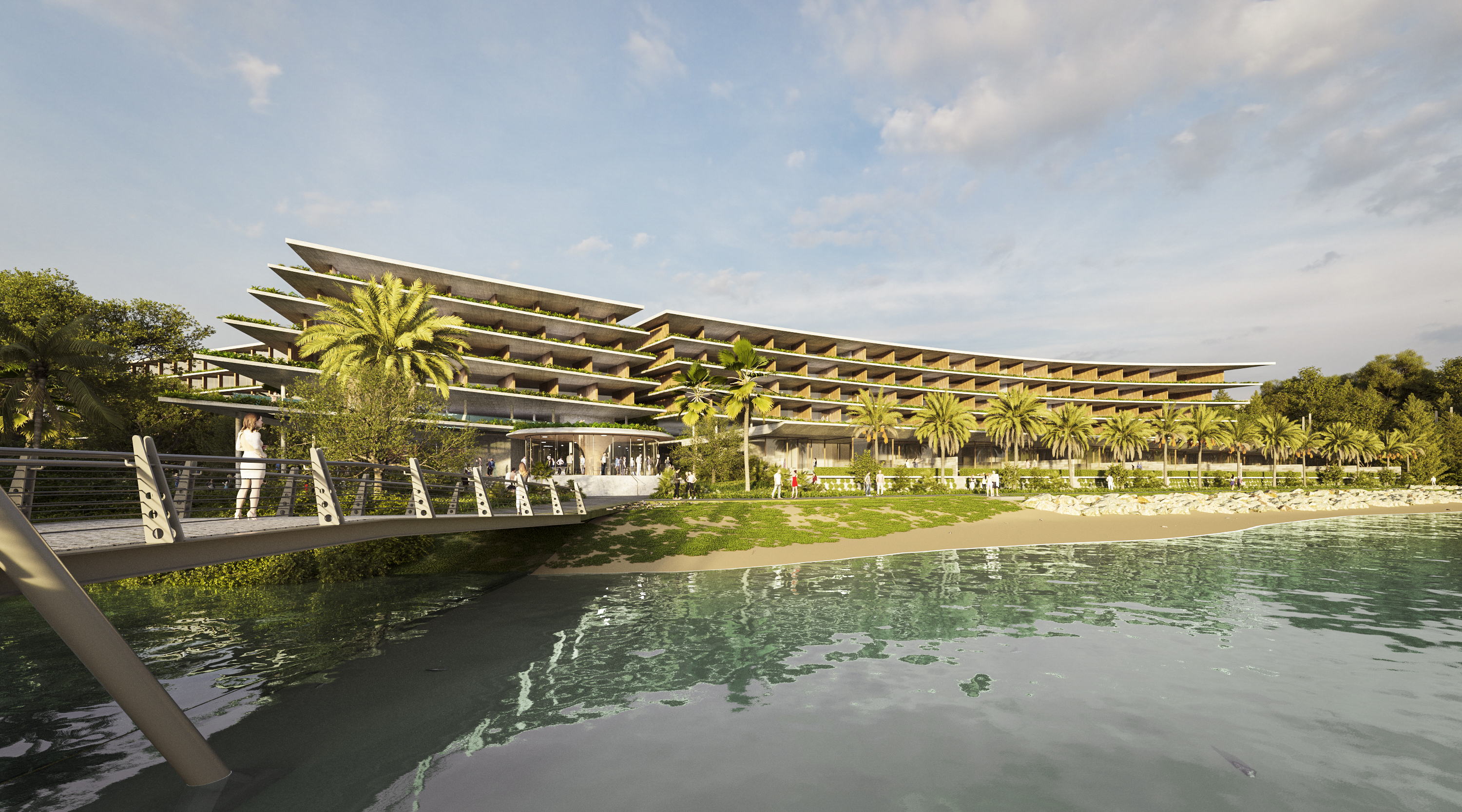
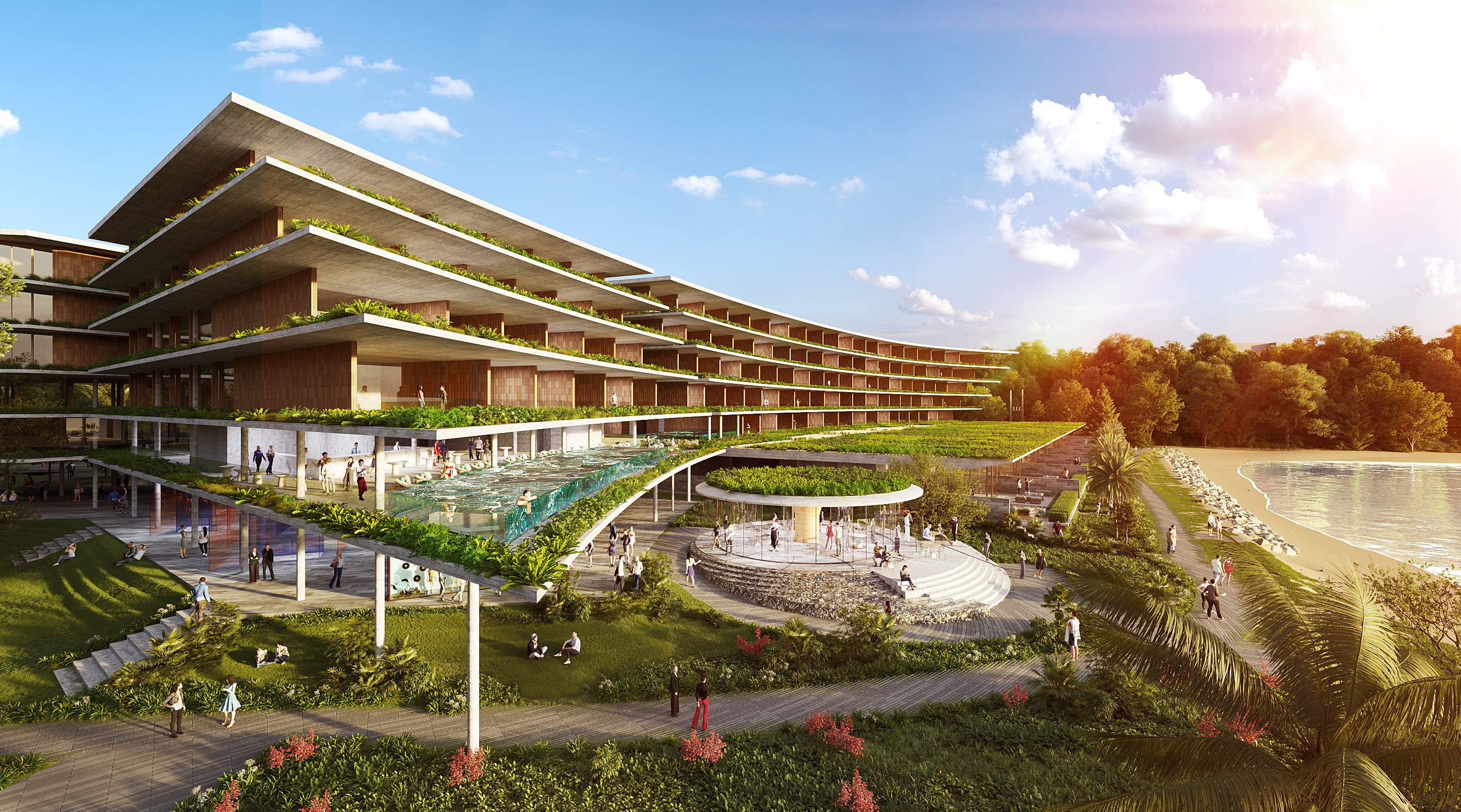
Little Mindil under threat!
Sign up for our newsletter here: https://actionnetwork.org/forms/sign-up-for-our-save-little-mindil-newsletter
See what is current: https://planinc.org.au/news/current-campaigns/293-save-little-mindil.html
Sign the petition here: https://actionnetwork.org/petitions/save-little-mindil
Download the current handout for your street: Current Handout
NT EPA Community Comments close 2 November 2021
The Northern Territory Environment Protection Authority have opened for community comments on the Little Mindil Development.
Here is the link to the web site: https://ntepa.nt.gov.au/consultation/north-one-hotel-and-apartments
These are the NT EPA documents
First is the guidline to submitting: Public submission Guidance
This is the developers referral form: Referral Form
This is the developers referral report: Referral Report
And these are the appendix:
appendix1a-design-response-package-part1.pdf
appendix1a-design-response-package-part2.pdf
appendix1a-design-response-package-part3.pdf
appendix-1b-architectural-drawing-package-part1.pdf
appendix-1b-architectural-drawing-package-part2.pdf
appendix2-landscape-concept.pdf
appendix3-stakeholder-engagement-plan.pdf
appendix4-Environmental-risk-assessment.pdf
appendix5-preliminary-site-investigation-contamination.pdf
appendix6-biological-study.pdf
appendix7-construction-environmental-management-plan.pdf
appendix8-acid-sulphate-management-plan.pdf
appendix9-engineering-services-report.pdf
appendix10-stormwater-management-plan.pdf
appendix11-hydraulic-assessment-report.pdf
appendix12-erosion-sediment-control-plan.pdf
appendix13-waste-management-plan.pdf
appendix14-traffic-impact-assessment.pdf
appendix15-visual-impact-study.pdf
appendix16-economic-benefits-snapshot.pdf
appendix17-noise-impact-assessment.pdf
appendix18-wind-impact-study.pdf
appendix19-archeological-assessment-report.pdf
appendix20-heritage-impact-assessment.pdf
appendix21-biting-insects-management-plan.pdf
appendix22-greenhouse-gas-assessment.pdf
Urbanscope to the Development Consent Authority in September 2021
Below is the appplication that was submitted by Urbanscope to the Development Consent Authority in September 2021. Community submissions are closed except for those who arranged an extension.
Click here to reach the attachments.
Read on ...
Currently listed at the Development Consent Authority is:
Friday, 3 September 2021 – closes Midnight Monday, 4 October 2021
Address: Lot 07651 Town of Darwin 25 GILRUTH AVE THE GARDENS Current Zones: MZ (Multi Zone)
Proposed Development: Hotel/motel and serviced apartments with ancillary bar-public and market in 2 x 6 storey and 3 x 1 storey buildings with ground level and semi-basement car parking
Requested Variations:
We know this site as Little Mindil, at the end of this article we have all the attachments to make it easier for the community to get access to this information. There was a long campaign to establish the public open space at Little Mindil. If you read the list of consultations that have been carried out we see that community have been omitted to date.
This is foreshore land and should always remain public open space.
This is an essential part of the total public recreational Mindil Beach Precinct, of which the Market site, the Golf Course, Waratah Oval, and the Botanic Gardens are also essential parts.
This whole area, next to the sea at Fannie Bay, is ringed by a high escarpment, which together forms a natural amphitheatre.
The NT Government made an agreement by which the large Little Mindil space was saved for the open relaxed recreational use of the people of Darwin. We need this open space area even more now, with a denser population in CBD.
Is the NT Government now going to change its mind, renege, and abandon the rights of the residents of Darwin at this point in time?
Here are the attachments
Attachment A - Title
Attachment B - Landscape Concept
Attachment C - Visual Impact Study
Attachment D - Stormwater Management Plan
Attachment E - Engineering Services Report
Attachment F - Hydraulic Assessment Report
Attachment G - Traffic Impact Assessment
Attachment H - Noise Impact Assessment
Attachment I - Desktop Environmental Wind Study
Attachment J - Bar-Public Plan of Management
Attachment K - Archeological Assessment Report
Attachment L - Heritage Impact Assessment
Attachment M - Erosion _ Sediment Control Plan
Attachment N - Preliminary Site Investigation - Contamination
Attachment O - Bulk Earthworks_ Roadworks _ Drainage Plan
Attachment P - Biting Insects Management Plan
Attachment Q - Survey Plan
Attachment R - PSA Map of Lot 7651
Attachment S - Covenants
Little Mindil Design Response Package
Attachment T - Council Authority to Submit DA
Little Mindil Architectural Drawing Package
Attachment U - List of Stakeholder Engagement Meetings
Little Mindil - Statement of Effect (R1)
Little Mindil - Statement of Effect (R1) ed note there are two of these in the application?
Morie information to follow.
https://www.abc.net.au/news/2021-09-08/nt-little-mindil-development-darwin-sacred-site/100444474
Posted in Community Alert
PLANNING ALERT - 4 BLAKE ST, The GARDENS
Exhibition Period:
Friday, 28 May 2021 - Midnight Friday, 25 June 2021
Address:
Lot 07820 Town of Darwin
4 BLAKE ST
THE GARDENS
Current Zones:
SD46 (Specific Use)
Proposed Development:
67 x 2 and 34 x 3 bedroom dwellings-multiple and ground level commercial tenancies in a seven-storey building (comprising two towers) plus one level of basement car parking
Requested Variations:
No key variations identified. Read the application for full details.
The application is for consent to develop Lot 7820 for 101 dwellings-multiple and 250 m2 of ground floor retail and commercial floor space in a 7-storey building comprising two towers, set in landscaped surrounds, together with basement and undercroft parking.
The site is subject to the provisions of Zone SD46 in the NT Planning Scheme. An essential requirement of Zone SD46 is that the development is to contribute to improving the amenity of the Blake Street Precinct as an inner-city mixed use area by creating a landmark development through high architectural quality and distinctive streetscapes – see clause 3(a) of SD46. A proposal in 2018 was found by NT Civil and Administrative Tribunal (NTCAT) not to be a landmark development, and a Notice of Determination issued by DCA to consent to the application was revoked1 . There is no definition of “landmark” or “landmark development” in the Planning Act or Planning Scheme. In the course of its review of the 2018 proposal, NTCAT considered numerous definitions of these terms put forward by various experts. It settled on the definition of “landmark development” articulated by architect Ian Mitchell, then Principal of Conrad Gargett Architects.
https://planinc.org.au/images/Blake04/110290710_s_46_Report_Lot_7820_2021_05_20.pdf
https://planinc.org.au/images/Blake04/10290712_Annexure_1_-_Ian_Mitchell_Design_Review_Report_210325.pdf
https://planinc.org.au/images/Blake04/110290714_Annexure_2_-_ELYSIUM_GREEN_Design_and_Community_Impact.pdf
https://planinc.org.au/images/Blake04/110290716_Annexure_3_-_NatHERS_Energy_Rating_Reports.pdf
https://planinc.org.au/images/Blake04/110290718_Annexure_4_-_SD46.pdf
https://planinc.org.au/images/Blake04/110290720_Annexure_5_-_CoD_advice_and_Traffic_Impact_Assessment.pdf
https://planinc.org.au/images/Blake04/110290722_Architectural_Drawings_Part_1.pdf
https://planinc.org.au/images/Blake04/110290722_Architectural_Drawings_Part_2.pdf
https://planinc.org.au/images/Blake04/110290722_Architectural_Drawings_Part_3.pdf
https://planinc.org.au/images/Blake04/110290722_Architectural_Drawings_Part_4.pdf
https://planinc.org.au/images/Blake04/110290722_Architectural_Drawings_Part_5.pdf
https://planinc.org.au/images/Blake04/110290722_Architectural_Drawings_Part_6.pdf
https://planinc.org.au/images/Blake04/110290722_Architectural_Drawings_Part_7.pdf
https://planinc.org.au/images/Blake04/110290722_Architectural_Drawings_Part_8.pdf
https://planinc.org.au/images/Blake04/110290722_Architectural_Drawings_Part_9.pdf
https://planinc.org.au/images/Blake04/110290722_Architectural_Drawings_Part_10.pdf
https://planinc.org.au/images/Blake04/110290722_Architectural_Drawings_Part_11.pdf
https://planinc.org.au/images/Blake04/110290722_Architectural_Drawings_Part_12.pdf
https://planinc.org.au/images/Blake04/110290722_Architectural_Drawings_Part_13.pdf
https://planinc.org.au/images/Blake04/110290722_Architectural_Drawings_Part_14.pdf
https://planinc.org.au/images/Blake04/110290722_Architectural_Drawings_Part_15.pdf
https://planinc.org.au/images/Blake04/110290752_Landscape_Drawings.pdf
https://planinc.org.au/images/Blake04/110290722_Architectural_Drawings_Part_11.pdf
Posted in Community Alert
Media Release - Lee Point Outrage
https://www.abc.net.au/news/2022-09-24/lee-point-darwin-gouldian-finches-defence-housing-development/101452040?fbclid=IwAR2UywS1ap5qFyA6hZdj1VxN2mMMGgWOugzGHvJ-PUDR8HqUwPWXoDlQ-UQ
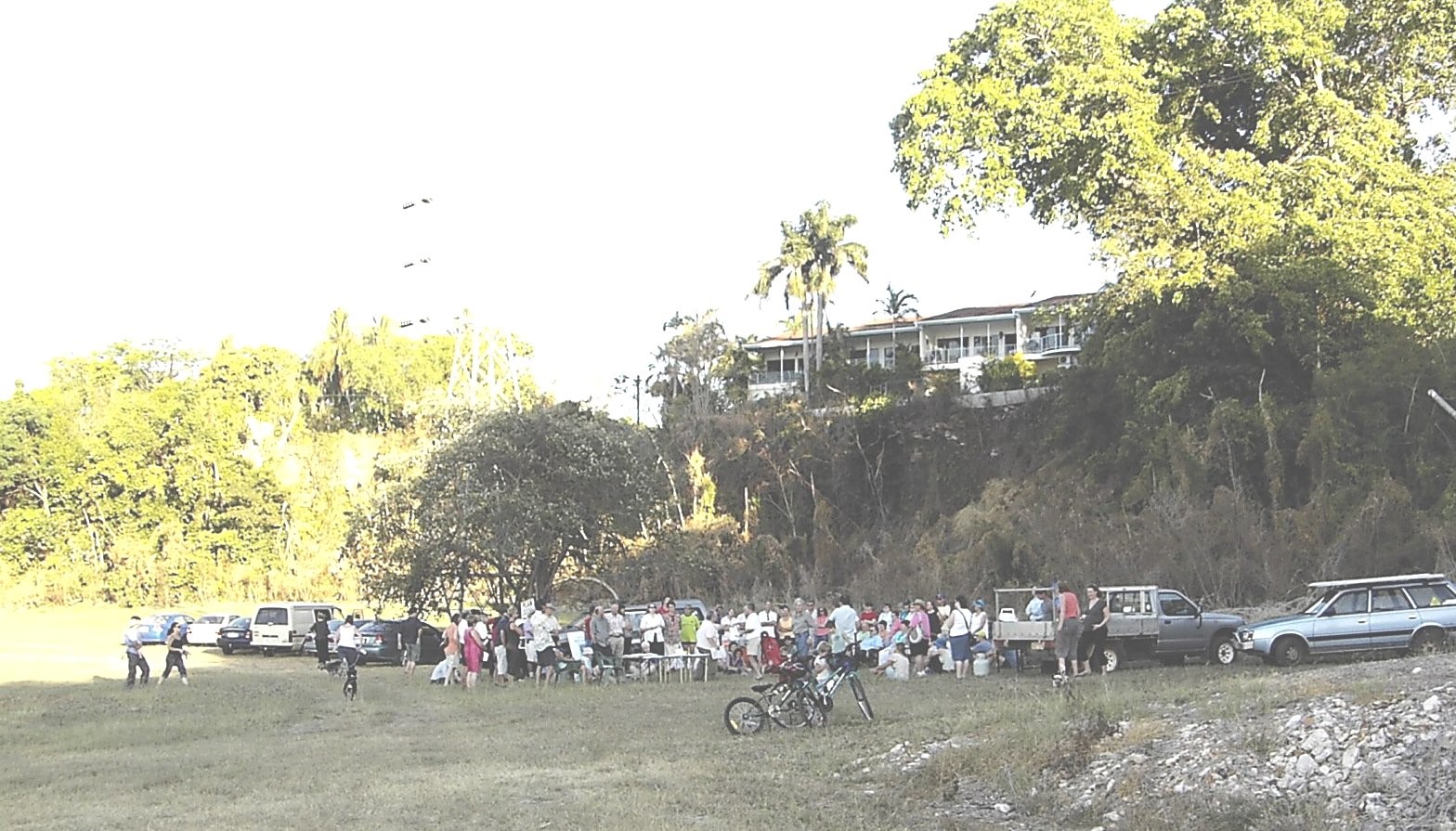
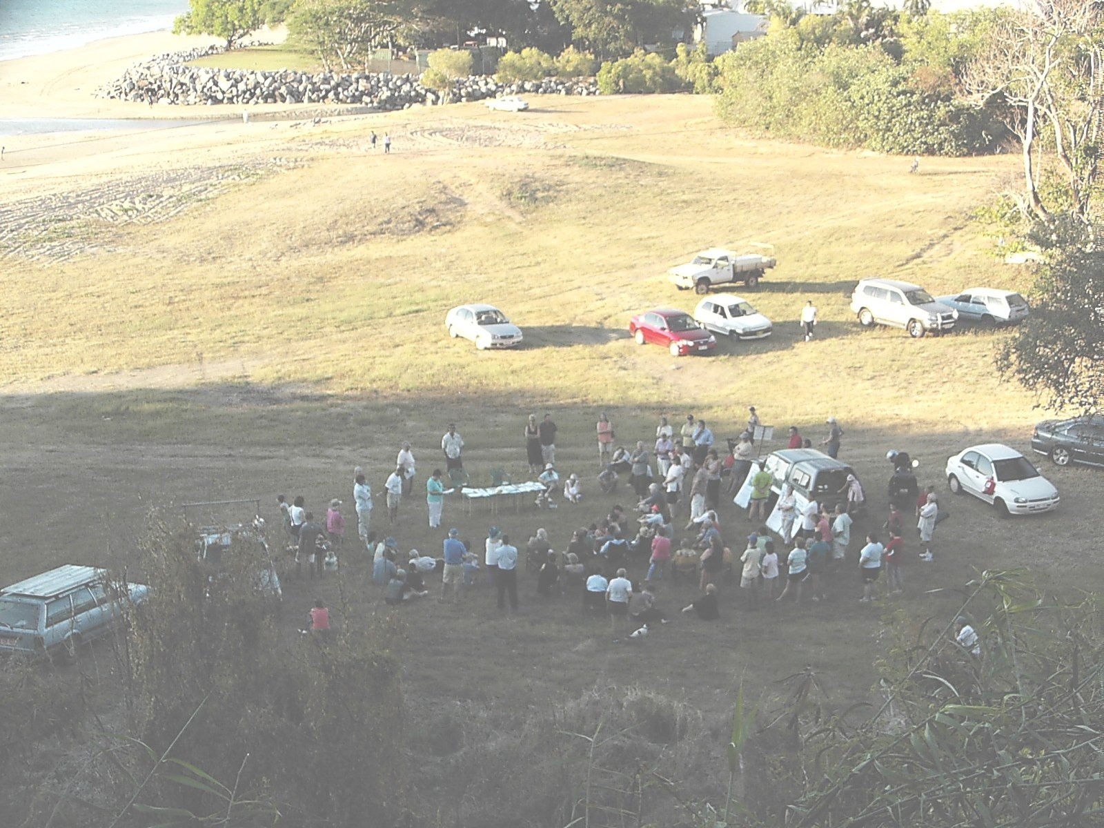
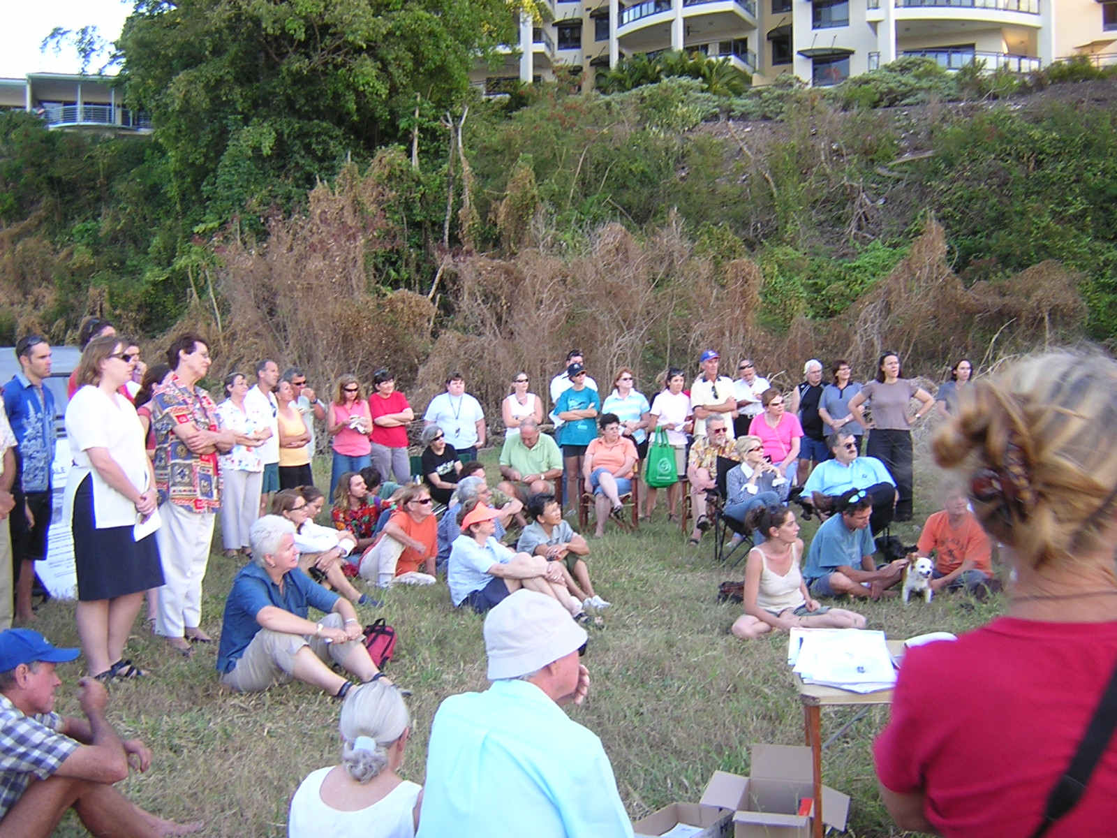
Public meeting Thursday 27 May, 5.15pm at Lee Point
- Darwin residents left the public meeting at Lee Point on Thursday outraged that the proposed housing development would harm nature and they were going to lose their enjoyment of Lee Point. Defence Housing Australia (DHA) has proposed to house thousands of people at Lee Point. Close to 100 Darwin residents attended the meeting.
.
- Nick Kirlew and Margaret Clinch from Planning Action Network Inc (a volunteer community group) said that community consultation had not been properly done and as such the proposal to house thousands of people at Lee Point had very little community support. Mr Nick Kirlew said over 1000 people had signed the on-line petition which calls on the NT Parliament to place a moratorium on the current development proposal for Lee Point until the NT Planning Commission has developed a comprehensive Area Plan for the whole of Lee Point.
- Ian Redmond from Friends of Lee Point (a volunteer community group) said that Lee Point is a part of Darwin that makes Darwin special, and that very few cities have a reserve like Lee Point on their doorstep. He believed that housing thousands of people at Lee Point was unnecessary, costly for the taxpayer and amounted to an urban sprawl. He also said that the DHA housing should be located near jobs and transport in line with the Australian Government’s Smart Cities Plan.
- David Percival (Friends of Lee Point) said that Lee Point was Darwin’s most important environmental asset and needed to be protected. He believed the impact of housing thousands of people at Lee Point would destroy the surrounding environment forever.
-
Gavin O’Brien from BirdLife Top End said that the migratory shorebirds had already been partly affected by nearby housing development.
He explained how the way that human and canine disturbance can impact the roost and said that these impacts could increase with further development.
- Martin Boland from Darwin Off Road Cyclists said that Lee Point was enjoyed by many cyclists because of its natural setting and had become particularly important during the time of COVID. He believed that cycling at Lee Point was good for mental health and that Lee Point should be conserved for public use.
- Robert Marchant a long-term Darwin tour operator said he did not support housing thousands of people at Lee Point and it would not promote tourism in Darwin. He believed there were much better places to locate housing in Darwin and did not want to see a pristine forest destroyed.
- Many people present at the meeting felt that most of Lee Point should become a conservation reserve and be used to help promote Darwin.
- The (100) people present at the meeting called on the NT Government to stop the bulldozers until there is a comprehensive Area Plan in place for the whole of Lee Point.
CONTACT: Nick Kirlew - Planning Action Network 0447 499 794, Ian Redmond - Friends of Lee Point 0427 796 470
Posted in Current Campaigns
NORTHERN TERRITORY OF AUSTRALIA
Planning Act - sections 54 and 55
DEVELOPMENT PERMIT DP19/0050
DESCRIPTION OF LAND THE SUBJECT OF THE PERMIT
Lot 09370 Town of Nightcliff
544 LEE POINT RD, LEE POINT
Sign the petition here: Save Lee Point Petition (actionnetwork.org)
APPROVED PURPOSE
To use and develop the land for the purpose of a subdivision to create 282 in 5 stages, in accordance
with the attached schedule of conditions and the endorsed plans.
VARIATIONS GRANTED
Clause 11.2.3 (Lot Size and Configuration in Residential Subdivisions) of the Northern Territory
Planning Scheme.
BASE PERIOD OF THE PERMIT
Subject to the provisions of sections 58, 59 and 59A of the Planning Act, this permit will lapse two
years from the date of issue.
DAWN PARKES
Delegate
Development Consent Authority
Page 1 of 7
DEVELOPMENT PERMIT
DP19/0050
SCHEDULE OF CONDITIONS
CONDITIONS PRECEDENT
1. Prior to the endorsement of plans and prior to the commencement of works (including site
preparation), amended plans are to be submitted showing:
(a) A full set of amended detailed subdivision plans and other supporting reports and plans,
reflecting the design changes made during assessment of the application, including the
demonstration of compliant building envelopes where a variation to Clause 11.2.3 (Lot Size and
Configuration in Residential Subdivisions) has not been granted.
The above is to be completed to the satisfaction of the consent authority.
2. Prior to the endorsement of plans and prior to the commencement of works (including site
preparation), the proponent is to prepare a Construction and Environmental Management Plan.
The Plan is to address waste management, traffic control, haulage routes, stormwater drainage,
and how Council land will be managed during construction, to the requirements of the City of
Darwin.
The Plan is also to address dust, noise and vibration impacts, and waste management, and
include processes for:
• communicating anticipated impacts of construction to stakeholders;
• the reporting of, and responding to complaints; and
• identifying when there are unexpected and unacceptable impacts to stakeholders and amending
construction practices as appropriate,
on the advice of the Environment division, Department of Environment and Natural Resources.
The Plan must demonstrate compliance with NT EPA Noise Guidelines for Development Sites,
and the NT EPA Noise Management Framework Guideline, and is also to include scope for
regular review and updates and include the schedule for construction stages. The above is to
be completed to the satisfaction of the consent authority.
3. Prior to the endorsement of plans and prior to the commencement of works (including site
preparation), the design and specifications of the on-site collection of stormwater and its discharge
into the City of Darwin stormwater drainage system or another acceptable location shall be
submitted to and approved by the City of Darwin, Medical Entomology, Department of Health
and Crown Land, to the satisfaction of the consent authority. The stormwater design should be
completely free draining to avoid the potential for mosquito breeding during low flow periods. All
discharge drains must be fitted with concrete low flow inverts that terminate at a free draining
tidal area. Access to, and maintenance of the end of point discharge drains must be clarified
and accepted by all relevant parties. The design of the stormwater infrastructure must consider
the sub-staging of the development to manage the quality of stormwater.
4. Prior to the endorsement of plans and prior to the commencement of works (including site
preparation), the developer is to prepare a water quality monitoring plan for Buffalo Creek,
including baseline monitoring and monitoring of any additional pollutant loads from the subdivision,
with any mitigation measures identified, on the advice of Water Resources, Department of
Environment and Natural Resources, to the satisfaction of the consent authority.
Page 2 of 7
5. Prior to the endorsement of plans and prior to the commencement of works (including site
preparation), the developer is to prepare a weed management plan to address ongoing weed
management, on the advice of Weed Management Branch, Department of Environment and
Natural Resources, to the satisfaction of the consent authority.
6. Prior to the endorsement of plans and prior to the commencement of works (including site
preparation), a landscape plan is to be prepared and must be generally in accordance with the
landscape concept submitted, and is to address landscaping details for all proposed road reserves
and public areas, to the approval of the City of Darwin, to the satisfaction of the consent authority.
The plans are to demonstrate as little clearing as possible.
7. Prior to the commencement of works, an Erosion and Sediment Control Plan (ESCP) is to be
submitted to and approved by the consent authority on the advice of Rangelands, Department
of Environment and Natural Resources.
The ESCP must be developed by a Certified Professional in Erosion and Sediment Control
(CPESC) and should detail methods and treatments for minimising erosion and sediment loss
from the site during both the clearing and establishment phases of the development.The ESCP
should also:
• be cross-referenced with other relevant environmental management plans to ensure
consistency;
• include details of both temporary and permanent erosion and sediment control measures
including for all stages of the development (pre, during and post works);
• comprise an over-arching strategic document outlining the principals, practices and methods
to be implemented, as well as site-specific dimensional plans identifying the location of works
and prescribed controls, and be accompanied by standard drawings and construction notes;
• include information regarding the proposed timing and stage of works, site manager contact
details, maintenance and monitoring requirements, and reporting procedures; and
• have the implementation regularly monitored by a suitably qualified third party auditor.
Information regarding erosion and sediment control and ESCP content is available at
www.austieca.com.au and the NTG website: https://nt.gov.au/environment/soil-land-vegetation.
The ESCP should be emailed for assessment to: This email address is being protected from spambots. You need JavaScript enabled to view it..
8. Prior to the endorsement of plans and prior to the commencement of works (including site
preparation), a site earthworks plan indicating finished levels of all proposed lots is to be submitted
to and approved by the City of Darwin to the satisfaction of the consent authority. All cut and fill
works are to be designed to eliminate the need for excessive cut/fill/retaining wall works for the
proposed lots.
9. Prior to the endorsement of plans and prior to the commencement of works (including site
preparation), the traffic impact assessment report submitted with the application is to be revised
to address intersection priority and minimum collector street carriageway widths, to the
requirements of the City of Darwin, to the satisfaction of the consent authority.
10.Prior to the endorsement of plans and prior to the commencement of works (including site
preparation), public transport details including bus stop locations and designs, and a route that
considers the staging of the development are to be provided to the requirements of Transport
and Civil Services, Department of Infrastructure, Planning and Logistics, to the satisfaction of
the consent authority.
Page 3 of 7
11.Prior to the commencement of works, the developer is to submit an updated water and sewer
infrastructure master plan to Water Services, Power and Water Corporation, to the satisfaction
of the consent authority.The master plan is to address the development together with the related
subdivision of Lot 4873, Town of Nightcliff to the west of Lee Point Road.
12.Prior to the commencement of works, a proposed zoning plan must be submitted to and approved
by the consent authority. The zoning plan must be consistent with the description given in the
application and is to address the whole of the subdivision including the proposed zoning for the
end of point discharge drains.
GENERAL CONDITIONS
13.The works carried out under this permit shall be in accordance with the drawings endorsed as
forming part of this permit.
14.The development must proceed in the order of stages as shown on the endorsed plan unless
otherwise agreed in writing by the consent authority.
15.The owner of the land must enter into agreements with the relevant authorities for the provision
of water supply, sewerage facilities, electricity services and telecommunication services to each
lot shown on the endorsed plan in accordance with the authorities' requirements and relevant
legislation at the time.
16.All existing and proposed easements and sites for existing and required utility services must be
vested in the relevant authority for which the easement or site is to be created on the plan of
subdivision submitted for approval by the Surveyor General.
17.Any developments on or adjacent to any easements on site shall be carried out to the
requirements of the relevant service authority to the satisfaction of the consent authority.
18.All proposed roads to be created on the plan of subdivision submitted for approval by the Surveyor
General must be dedicated to the relevant Northern Territory or local government authority.
19.The Construction and Environmental Management Plan is to be implemented on the advice of
the City of Darwin, and Environment, Department of Environment and Natural Resources, to the
satisfaction of the consent authority.The Plan is also to remain publically available for the duration
of construction.
20.Engineering design and specifications for the proposed and affected roads, street lighting,
stormwater drainage, site earthworks, vehicular access, pedestrian/ cycle corridors and
streetscaping are to be to the technical requirements of City of Darwin, to the satisfaction of the
consent authority and all approved works constructed at the owner’s expense.
21.Before the use commences the owner must, in accordance with Part 6 of the Planning Act, pay
a monetary contribution to the City of Darwin for the upgrade of local infrastructure, in accordance
with its Lee Point Road Roadwork Contribution Plan, to the satisfaction of the consent authority.
22.Stormwater is to be collected and discharged into the drainage network to the technical standards
of the City of Darwin, Medical Entomology, Department of Health, and Crown Land, to the
satisfaction of the consent authority.
Page 4 of 7
23.The applicant is to demonstrate all discharge drains, including the end of point of the drains,
include suitable access to allow for maintenance on the advice of Medical Entomology,
Department of Health, to the satisfaction of the consent authority.
24.The landscaping works shown on the endorsed plans must be carried out and completed to the
requirements of the City of Darwin, and Medical Entomology, Department of Health, to the
satisfaction of the consent authority.
25.All works relating to this permit are to be undertaken in accordance with the approved Erosion
and Sediment Control Plan to the requirements of the consent authority on the advice of
Rangelands, Department of Environment and Natural Resources.
26.The water quality monitoring plan for Buffalo Creek is to be implemented on the advice of Water
Resources, Department of Environment and Natural Resources, to the satisfaction of the consent
authority.
27.The weed management plan is to be implemented on the advice of Weed Management Branch,
Department of Environment and Natural Resources, to the satisfaction of the consent authority.
28.Any offset or offset management plan required by the Australian Government with respect to
the significant residual impact to the black-footed tree-rat (Mesembriomys gouldii gouldii) is to
be completed, on the advice of Flora and Fauna, Department of Environment and Natural
Resources, to the satisfaction of the consent authority.
29.A qualified person, under section 68 of the Waste Management and Pollution Control Act, must
provide certification that the site is suitable for the intended use on the advice of Environment,
Department of Environment and Natural Resources, to the satisfaction of the consent authority.
30.The proponent must ensure that only clean fill (virgin excavated natural material) is accepted
and that the fill has been adequately assessed as being suitable for its intended use, on the
advice of Environment, Department of Environment and Natural Resource, to the satisfaction
of the consent authority.
31.Before the issue of titles, the developer is to provide written confirmation from a suitably qualified
person that the rural residential lots are entirely unconstrained and free draining, and suitable
for their intended purpose, to the satisfaction of the consent authority.
32.Before the issue of titles, the developer is to provide written confirmation (in the form of plans
or drawings) demonstrating that all lots less than 600m² for single dwellings allow for future
vehicle access via a single driveway unrestricted by street infrastructure (including any power,
water, sewer, or stormwater infrastructure) which demonstrates that a 3.5m driveway can be
located on each lot whilst ensuring that each lot’s street frontage has a minimum continuous
length of 6.5m, to the satisfaction of the consent authority.
33.Pursuant to section 34 of the Land Title Act, a Caution Notice shall be lodged with the Registrar
General on the parent parcel to include the following advice on all proposed lots indicated on
the endorsed drawings to be located within the 1.7km odour buffer from the Leanyer Sanderson
Wastewater Treatment Plant.
The Caution Notice is to state that:
“This lot:
Page 5 of 7
• occurs within the identified odour buffer for the Leanyer Sanderson Wastewater Treatment
Plant; and
• may be subject to occasional odours associated with the operation of the Leanyer Sanderson
Wastewater Treatment Plant.”
Evidence of lodgement on the parent parcel shall be provided to the satisfaction of the consent
authority.
34.Pursuant to section 34 of the Land Title Act, a Caution Notice shall be lodged with the Registrar
General on the parent parcel to include the following advice on all proposed lots indicated on
the endorsed drawings to be located within the biting insect buffer.
The Caution Notice is to state that:
“This lot:
• occurs within the biting insect buffer; and
• that the lot is subject to seasonal mosquito and biting midge pest problems arising from the
adjacent mangroves of Buffalo Creek and tidal marshes and mangroves in Leanyer Swamp.”
Evidence of lodgement on the parent parcel shall be provided to the satisfaction of the consent
authority.
NOTES
1. The Power and Water Corporation advises that the Water and Sewer Services Development
Section (This email address is being protected from spambots. You need JavaScript enabled to view it.) and Power Network Engineering Section
(This email address is being protected from spambots. You need JavaScript enabled to view it.) should be contacted via email a minimum of one
month prior to construction works commencing to determine the Corporation’s servicing
requirements, and the need for upgrading of on-site and/or surrounding infrastructure.
2. If you choose nbn to service your development, you will need to enter into a development
agreement with nbn. The first step is to register the development via
http://www.nbnco.com.au/develop-or-plan-with-the-nbn/new-developments.html once registered
nbn will be in contact to discuss the specific requirements for the development. Nbn requires
you to apply at least 3 months before any civil works commence. All telecommunications
infrastructure should be built to nbn guidelines found at
http://www.nbnco.com.au/develop-or-plan-with-the-nbn/new-developments/builders-designers.html.
3. The Northern Territory Environment Protection Authority advises that construction work should
be conducted in accordance with the Authority’s Noise Guidelines for Development Sites. The
guidelines specify that on-site construction activities are restricted to between 7am and 7pm
Monday to Saturday and 9am to 6pm Sunday and Public Holidays. For construction activities
outside these hours refer to the guidelines for further information.
4. Any proposed works which fall within the scope of the Construction Industry Long Service Leave
and Benefits Act must be notified to NT Build by lodgement of the required Project Notification
Form. Payment of any levy must be made prior to the commencement of any construction activity.
NT Build should be contacted via email (This email address is being protected from spambots. You need JavaScript enabled to view it.) or by phone on 08 89364070 to
determine if the proposed works are subject to the Act.
Page 6 of 7
5. As part of any subdivision, the parcel numbers for addressing should comply with the Australian
Standard (AS/NZS 4819:2011). For more information contact Survey and Land Records
This email address is being protected from spambots. You need JavaScript enabled to view it. 08 8995 5354. The numbers shown on the plans endorsed as
forming part of this permit are indicative only and are not for addressing purposes.
6. All new roads, including alterations and extensions to existing roads, are required to be named
under the Place Names Act. You should immediately make application to the Place Names
Committee to commence the road naming process. Contact the Place Names Unit on 08 8995
5333 or This email address is being protected from spambots. You need JavaScript enabled to view it..
7. The Northern Territory Environment and Protection Authority has advised that the proponent
must comply with their General Environment Duty provided by section 12 of the Waste
Management and Pollution Control Act.
8. There are statutory obligations under the Weeds Management Act to take all practical measures
to manage weeds on the property. For advice on weed management please contact the
Rangelands division, Department of Environment and Natural Resources.
9. The City of Darwin provides advice regarding the provision of street trees to be planted within
Council’s proposed road reserve, including the provision of a planting schedule, specification
for quality tree stock, species selection, and the maintenance and establishment periods. Please
contact the City of Darwin for advice on street trees.
10.Passenger Transport Planning, Department of Infrastructure, Planning and Logistics request
that the developer remain in regular contact with the division and to confirm details of the location
and design of bus stops as the development progresses.
Page 7 of 7
Posted in Current Campaigns
Greetings Friends,
What will happen to traffic volumes if the proposed development to house 3000 people (population of Tennant Creek) at Lee Point goes ahead? Who pays for these upgrades?
Vanderlin/Lee Point Road roundabout (looking east) – morning peak hour – Sept 2020

The NT Government is inviting the public to contribute to a Vanderlin Drive/Lee Point Road Intersection Planning Study: https://haveyoursay.nt.gov.au/vanderlin-drive-lee-point-road-intersection-planning-study
Please send your comments to the NT Government (see link above), consultation ends Friday 18 Dec 2020.
Alternatively you can send comments to your local member or newspaper on this issue. Attached FYI is another copy of "It's Your Lee Point" flyer plus paper on "Improving the cost benefit of future defence housing in Darwin."
rgds
Ian and Gayle
Friends of Lee Point
04 277 96 470
https://planinc.org.au/images/documents/Lee_Point-Letter_FLP_to_NT_Planning-ATT_A.pdf
https://planinc.org.au/images/documents/Lee_Point-Letter_FLP_to_NT_Planning-ATT_B.pdf
Posted in Blog & Opinion
-
INTRODUCTION
If you make a submission please do, by the cut off date of 11 December, 2020.
Please make your submission individual, including your name and address, and email if you have one.
The more individual submissions the better. They all need to be different.
For your possible interest, I attach here a link to the submission prepared on this application
by the Rapid Creek Land Care Group. This is a public document, and they are happy for anyone to make use of it.
It contains a lot of information.
http://www.rapidcreek.org.au/documents/docUploads/RCLGsubmission%20-%20Boulter%20Road%20December%202020%20REVISED.pdf
-
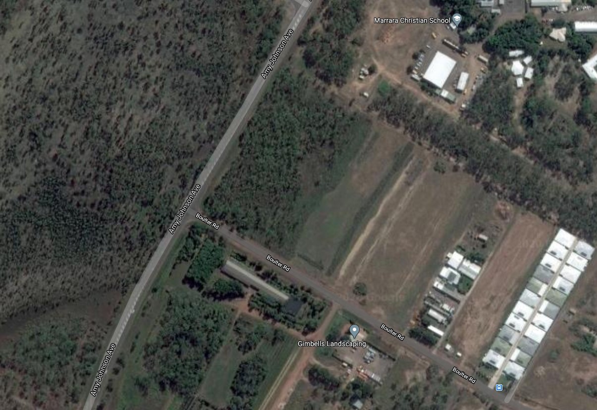
ABOUT THE APPLICATION
The application is for permission to subdivide the land on Section 04106, at 1 Boulter Road, Berrimah into 36 lots for housing, with one park lot.
The site measures 7.44 hectares, and is at the corner of Amy Johnston Avenue and Boulter Road.
The land consists of three land use zones. These are Conservation (CN), Rural Residentia l(RR) and Low Density Residential (LR) each occupying about one third of the big lot.
You could access a full copy of the application by searching on Google using keywords ‘Developing applications online - Northern Territory’, then ‘Planning Notices’. You could instead use ‘www.ntlis.nt.gov.au//planning/ita/dar/list.
Next clicking the VIEW PROPOSAL button downloads all six sections of the application.
This may be more information than you want, as this application itself is very complex, and confusing.
If you wish, you may use the MAKE SUBMISSION button to make your submission online.
Also make yourself a copy of your submission before you send it off. (Ask for an acknowledgement).
Otherwise, you can use a PDF email, and send it to Development Assessment Services (DAS) at This email address is being protected from spambots. You need JavaScript enabled to view it..
Prepared submissions can also be hand delivered to:
First Floor Desk,
Energy House,
18-20 Cavenagh Street,
GPO Box 1680,
Darwin, NT 0801
-
NOTES FOR SUBMITTERS - SOME ISSUES
I hope this long list can help you make up a submission in time.
No response to the geographical situation of this land in a large catchment.
Poor physical layout of the proposed estate.
Focus is on over exploitation.
No empathy with the natural environment.
Lack of understanding of flood prone land inside and outside the Section.
Ignorance of the context of the Rapid Creek Catchment.
NTEPA should be involved in assessing the natural environment.
Conservation Zone should not be split between RR owners’ lots.
The layout of the RR and LR lots does not at all comply with the biting insects restriction.
Natural areas of the Conservation Zone cannot be reduced for any purpose.
Conservation zone, including should be excised to public ownership as the 'Marrara Wetland'.
Natural systems should be preserved.
No retention ponds to be built in the Conservation area.
No vegetation except weeds to be removed.
On Lot 04106 trees should be retained as much as possible.
NT Land Clearing Guidelines must be complied with.
Recommendations on land clearing too damaging because of mitigation ideas..
Concerns about water management on and off the site.
Remedying 0.15m 1% AEP Depth on 80% of Section 04106 surface, sounds very expensive.
Water run off down Rapid Creek must be clean.
Huge additional water runoff from 36 roofs, and new extra hardstand.
Flooding of Rapid Creek is already occurring at the Trower Road Bridge.
Clearing is continuing on International Airport land for commercial purposes.
Huge government moneys have been used on flood mitigation study for the catchment and houses in Rapid Creek Road.
Compliance is required with the Rapid Creek Management PLan.
The proposed roads are too narrow, and some other measurements may be questionable.
The Berrimah North Area Plan requires properly controlled run-off to avoid erosion and sediment.
An Erosion and Sediment Control Plan (ESCP) is required.
The Berrimah North Area PLan describes Boulter Road to be the FRONT STREET of a neighbourhood.
No Commercial neighbourhood yet exists, and there are not even any footpaths or bus stops in Boulter Road.
Neither is this present proposed layout conducive to creating an interactive neighbourhood with cosy shady places where families can gather, out of the sun. The present developments lack interest.
Nothing should occur until there is justice done by rehabilitating this land, No 1 Boulter Road after it was illegally cleared without NT Government penalty in 2014.
Please share with others if they are interested, but ask them to always send different submissions.
We would like to receive copies of some of your submissions.
Best Wishes
M A CLINCH
PLan: the Planning Action Network, Inc.
89271999.
Posted in Community Alert
Conveners Annual Report for 2019
PLan works for balanced planning and for better living environments for the people of the Northern Territory.
1. Introduction
This report covers our 2019 year but as the AGM is late it will include information from both 2019 and 2020. As ever there is so much going on and it is the community that is stepping up to keep our fair city and surrounds in good shape. Without you the Territory would be a very different place! What follows is in no particular order:
2. Current Issues
2.1 Reform Agenda
2019 - This round of consultation went through almost completely without including anything from the public. Using the “ask at Christmas” method favoured by NTG a significant round of their changes is poised to roll out. Among other issues it seems it will be easier for the government to achieve change and harder for those affected to be aware that the change is coming to their urban environment.
PLan made submissions to Central Darwin Area Plan. Subsequent to this the very major policy changes to a highly amended Planning Act where introduced.
Late in 2019 PLan joins with others in the community campaigning to keep “amenity” in the planning act. Say no to taking Community out of the Act is a strong widespread campaign. This has had minimum impact, due to a lack of understanding from the planners.
2020 - The Planning Amendment Bill, 2020 was introduced by the NT Government to the Legislative Assembly very soon after Christmas, on 13 February, 2020.
If passed by Parliament without change, the Bill would replace entirely the existing Planning Act of 1999.
Draft NTG Bill goes through the Scrutiny Committee.
Midyear this is passed by parliament, before the new election.
September - New Planning Scheme and Act Information Sessions are announced.
2.2 Flagstaff Park
2020 September - PLan meet with NT Planning Commission Chairman Dr David Ritchie on the future of Flagstaff park.
2.3 John Stokes Redevelopment
2019 - Plan noted the lack of Community Consultation on this development to the relevant minister.
2.4 Park Lighting
2019 – 2020 There have been long running campaigns on the installation of night lights to sporting venues across the city and surrounds.
2.5 Two Trees - Post Office carpark
Today’s newspaper (28/07/2019) rolls out the CDU move to the current Post Office Carpark picture yet again. The splitting of the CDU campus to four locations across Darwin and Palmerston is hailed as the next best thing since sliced bread for the CBD. There is the Banyan Tree and a much loved Milkwood of great age on the site. According to the university interpretation the Banyan is to survive the new building by use of an atrium.
Just before Christmas the Milkwood tree in the post office car park was taken out overnight. The tree was under consideration for heritage listing and the public rallied and managed to prevent the axe on the first day, but a police guarantee of a stay of execution did not prevent the cull before dawn the next day.
2.6 Bagot Park Millner
2019 - The upgrade of the velodrome has morphed into a park engulfing bicycle precinct. City of Darwin have run a “consultation process” which they thought had managed to get the approval of the bicycle organisations. Not listed as stakeholders, the community of Bagot Park are calling for a feasibility study. Amongst other issues public open space will be subsumed into this project.
This continued as a divisive issue, in the second half of the year Friends of Bagot Park engaged with COD to seek an understanding of what was planned.
2020 - City of Darwin continue to rehash the Bagot Park/Velodrome conundrum. Council has appointed a consultant engineering firm to undertake detailed design as per the consultation undertaken with the community.
Mid 2020 an unbriefed Cardno meet with Friends of Bagot in an inconclusive discussion on the future the park and surrounds. Friends of Bagot Park ramp up their campaign.
Late July a meeting with the Lord Mayor, CEO and others was held.
July - Heard last night, that the Velodrome item on the agenda had been moved from the Confidential section of the meeting to the open meeting.
A detailed report was presented on the circumstances leading to the NTG requesting City of Darwin to return the $8m funding for the Velodrome and Cycling Precinct. It included a plan for the park including the car park as was envisaged by the Cyclists.
2.7 Dead Sites – Asti Motel
One of Darwin’s notorious Dead Sites; the Asti Motel came up for renewal of its development permit. Eventually the applicants never completed the application leaving this unsightly location in limbo yet again.
2.8 Old Hospital Site
A proposal to create a playground on a portion of the Old Darwin Hospital site came up. In 2020 a fortune is spent on unplanned Asbestos control.
2.9 State Square and surrounds
The new underground Car Park at State Square did not quite fit underground requiring a change to the tree load the structure could carry. An above ground garden is subsequently created.
2.10 Building deals
To quote the NT News: “It comes after residents in a Darwin apartment complex raised concerns that a company owned by the wife of the building's developer was contracted to oversee cleaning, maintenance and repairs for $120,000 per year for 25 years.”
It appears the building also has the issue of the disbarred engineer and floor slabs.
2.11 When is a house not a home?
A three-story home with 32 rooftop air conditioners is applied for as a Single Dwelling but is eventually not approved to the relief of neighbours.
2.12 Hughes Avenue – Skywalk
2019 - $15m of NTG funds have been promised to the owners of the new waterfront hotel to construct a second waterfront skywalk. It would come up Hughes Avenue which is bounded by a significant and remnant Darwin stand of rainforest. Use of this publicly owned street was altered by City of Darwin briefly banning bicycles for safety reasons. That ban was soon retracted. The Skywalk will also overlook Government House. This introduces visual pollution and a question of safety for the Administrator as well as a less than optimal use of public resources.
2.13 Dead Sites – Westin Hotel
Mid 2020 pressure mounts on the developers of the Westin site to make good what is now an ugly eye sore.
CAMPAIGN: 'Waterfront Wharf 2 Foreshore to be returned to Citizens by the Landbridge Hotel & Jervois Park land remediated
GROUP: Friends of Waterfront Wharf 2, part of the PLan Network
DAY/DATE: Saturday 1st August, 2020
TIME: 4:00pm - 5:00pm
VENUE: Goyer Park, Kitchener Drive, Waterfront Wharf 2
2.14 East Point Throb Nightclub
May 2020 sees the Lord Mayor and City of Darwin aldermen endorsing a “pop up” nightclub at East Point Reserve. This is very divisive and eventually is overturned.
June 2020 - Tonight at the Council Meeting, the Motion put forth by Alderman Andrew Arthur (Waters Ward) for the establishment of an East Point Advisory Committee was passed - 9 votes to 3. The three Aldermen who voted against it were: Mick Palmer (Lyons Ward), Paul Arnold (Lyons Ward) and Jimmy Bouhoris (Richardson Ward).
2.15 Kulaluk, the stockpile and piles of fresh rock
2019 - In what is probably the longest running campaign to preserve and bring some logic to what is an amazing area of environmental diversity there has seen continued degradation by neglect. Land is being filled in preparation for more “Box Drop” style commercial warehouses. Gamba Grass is spreading unchecked causing a severe fire risk. Calls for a resolution to the illegal stockpile have fallen on deaf ears at NTG.
2.16 Double Block/ Dual Occupancy
During 2019 the ability to build two houses on one lot is established as prohibited in the planning scheme, but the minister retains and has used an override. A continuation of uncertainty in planning that gives to some and not to others.
2.17 Lee Point and Casuarina Coastal Reserve
This one just hurts, DHA are packing as many houses as they can cheek and jowl alongside Casuarina Coastal Reserve. The DHA to Darwin Community interface is broken.
An open boundary between thousands of people, cats and dogs and Casuarina Coastal Reserve is unacceptable. NTG should never have given the green light to an environmental travesty.
Mid 2020 Friends of Lee Point ramp up the concept of creating more park out of the now open space on Lee Point.
Public Meeting held Saturday 25th of July 2020 – well attended.
80% of the thirty-five attendees agreed to call on the Commonwealth and NT Government to immediately cease any development on the two affected areas.
July 2020 An application for a liquor licence for Muirhead appears and PLan objects.
2.18 Darwin City Council and CBD
2019 - There is a thought that City of Darwin should not be property developers. Combining with NTG to pump start the NT economy by road building and yet to be publicly released changes to key council infrastructure. It seems the residents will be the last to know.
The installation of controversial facial recognition technology across the city has seen the council back away by advising that technology will not be used.
A mooted plan to place public statues on the Esplanade send shivers up my spine.
March 2020 and the RSL move to the Esplanade becomes a focus for the Lord Mayor. Community response builds.
April 2020 The Lord Mayor reveals his desire to commercialise City of Darwin assets.
2.19 Esplanade Cenotaph Carpark and Deckchair Cinema
Mid 2020 Public awareness campaigns are running strongly on this controversial idea by the Lord Mayor. The Deckchair Cinema are facing a business destroying potential event and support for the Deckchair is strong.
There is strong community support for the returning of the space back into the Esplanade as flagged by the City Deal.
You are invited to a Community Event,
Date: Saturday 4th July 2020, Time: 4pm, Location: Darwin Esplanade Cenotaph Car Park
Agenda:
- Who owns Darwin Esplanade?
- The Deckchair Cinema is under threat.
- A promise is a promise to be kept - (Darwin City Deal page 13).
- Governance, provide for the interests and well-being of individuals and groups
The Deckchair petition eventually gets to over 11,000 signatures!
City of Darwin Tuesday 13/10/20 5:30pm 400 people attend and mob the public meeting at City of Darwin. Decision is removed from the agenda.
2.20 Little Mindil
2019 - This space was guaranteed as open space for the community. Now up for sale/sold what agreements are NTG insisting to preserve the promises of previous Chief Ministers?
Feb 2020 - This week SkyCity contractors cut down trees in the forest along the Little Mindil escarpment. Surveyors have also been sighted at Little Mindil. With the pending sale of Little Mindil is the community to lose the precious asset they fought hard for over a decade ago?
2.21 Sale of Lands Title Office
2019 - The privatising of building inspection has clearly introduced a mistrust in the process with many apartment buildings across the country (including 9 in Darwin) revealing faults that should never have been allowed. Recently NTG discovered it could sell our Land Titles function. Where this has happened interstate, costs have gone up astronomically. The function of the Land Titles Office is a public service and to avoid unforeseen issues this should remain so.
The government continued to support this concept.
2.22 Heritage Council and the Minister
The Heritage Council and the Minister continue to confound with their decisions. Recently the approval of an installation of a full-size container, solid wall and second floor veranda to the Knuckey Street side of Admiralty House could perhaps indicate a straying from the Heritage Value of the site.
Advice on our Heritage Listing application for Old Darwin Primary School brought a smile to my face, to quote … “Some structures associated with the Old School were demolished and/or subsumed by landfill, and the construction work had a significant effect on the setting of the Old Primary School”
2.23 Blake Street rezoning raises its head late in 2019
Lot 06907 Town of Darwin 25 BLAKE ST THE GARDENS.
The process is that first they rezone from Community Purpose to Specific Use Zone. This is what you are being asked to comment on.
"Rezone land to a SU (Specific Use Zone) to facilitate residential development in accordance with Zone HR (High Density Residential), Zone MR (Medium Density Residential) and specific non-residential activities."
2020 Just before the election
Eva Lawler Minister for Infrastructure, Planning and Logistics makes a new statement on a different matter.
STATEMENT ON 16 AND 25 BLAKE STREET, THE GARDENS
28 July 2020 - I have made the decision not to approve the rezoning of 16 and 25 Blake Street, The Gardens to Specific Use Zone. Rezoning would have facilitated high and medium density residential development.
2.24 Barneson Boulevarde completed
The controversial road was completed 9 months early but millions over budget due to the additional work to stabilise the mangrove end of the road. Also gets renamed.
2020 the bus interchange on Cavenagh Street is completed. A what a gem it is not.
2.25 AZRI Site sale large near rural block goes for direct sale
During the Christmas break this appears:
We refer, in this instance, to newspaper ads to sell 11.6 hectares of crown land at 155 Colonel Rose Drive Kilgariff (' for the purpose of a residential subdivision': NT News 13/12/19 p.43) and 658 Channel Island Road Wickham (' for the purpose of development and the operation of a minerals processing facility': NT News 14/12/19 p.42).
2.26 Cullen Bay
Feb 2020 $10m to be spent on public space upgrades at Cullen Bay.
2.27 Gamba Grass
March 2020 PLan writes to Minister pointing out the proliferation of Gamba Grass is creating fire hazards in the community.
2.28 National Aboriginal Art Gallery – Alice Springs Anzac Park
June 2020 Alice Springs community and council object to a land grab for Anzac Park to place a new Indigenous Art Gallery on land not approved by both local communities. NTG are using the lands Acquisition Act to override opposition.
3 Where to from here
PLan - the Planning Action Network Inc is a volunteer community group working for better urban and rural planning in the Northern Territory.
PLan collaborates with resident and community groups on matters including the built environment, heritage, cultural and environmental values of concern in the Northern Territory and Australia. PLan’s aim is to achieve, for the community, sustainability in terms of social, cultural, environmental and balanced long term economic impacts.
3.1 Public Facing
- Market Stalls - Jane and Josie take PLan out to the community at market stalls.
- 1 Planning Bazaars - During 2019 we ran Planning Bazaars which were public events where community members and groups would present their current strategies and issues.
- Action Network - PLan adopt online software which enables awareness campaigns which allow for concerned community members to direct letter write and email elected representatives and other parties.
- PLan presented at the Ripple Effect section of the Seabreeze Festival.
- PLan launch a Community Survey. https://planinc.org.au/news/current-campaigns-2/269-community-survey-2020.html
3.2 Web Site/Facebook/Newsletter
A lot of effort goes into getting a permanent record of planning decisions into the public domain. We run a web site, Facebook page, newsletter and regular emails, as well as maintaining our archives.
3.3 Casuarina Campus of CDU
PLan participated in workshops as to the future of Casuarina Campus which is being defunded and may require demolition of some of the existing buildings.
3.4 Committee
Our committee aims to meet on regular basis, and we welcome new blood. At our Winnellie Office are multiple projects that just require an owner to get them up and running. So, if you have some free time please feel free to put your hand up.
3.5 Grants
PLan joins with Bird Life NT on a Community Environment Grant on Shorebirds and Casuarina Coastal Reserve.
2020 August Plan applies for a History Grant Celebrating the 150th anniversary of the Landing of the Undersea Telegraphic Cable in Darwin
3.6 Plan memberships goes online
Thank you for your memberships and for the support of the PLan Committee.
Regards
Nick Kirlew
Convener 7/11/2020
Posted in Blog & Opinion
Mitchell Park Botanical Gardens/Nature Park initiative
An effort to make the suburb of Mitchell and the neighbouring part of Litchfield Shire into a nature park/botanical gardens is getting started.
Meetings
Just a quick reminder that the first of the regular get together meetings will be at the Palmerston Library Community Room tonight from 6pm to 7pm.
Meetings are the 2nd and 4th Wednesdays of each month at this venue. Pass the word around.
Hope to see you there.
Kindest regards,
Jim Young
0439 776 025
A summary of the initiative and an explanation of how things might be structured is as follows.
At the end of the day the park would still come under the purview of the Councils, but management of the park would be substantially delegated to the park's organising committee in accordance with its constitution.
There will be some initial infrastructure that the local Councils would be required to provide.
The access roads and getting water reticulation to the areas needing irrigation, etc. would go in first. With good planning we can keep water usage to a minimum.
After this initial expense, from then on it would only require occasional maintenance. There would also be a need for some earthworks around areas requiring substantial landscaping, such as the swamps, ponds, etc.
Once this is done the volunteers can move in and help with the paths and gardening.
For certain tasks, volunteers might be required to complete an induction/safety course, which could be subsidised by the Councils.

Please appreciate that it is intended to have the vast bulk of the park remain effectively pristine bush.
The basic formula for how much of the park this is can be obtained by looking at the Zoning Map.

The green conservation areas will stay virtually untouched, except for access. The orange Future Development zoning area will remain at least 50% pristine bush.
Most of the park would be paths through the bush. Consequently these areas won't require much maintenance at all.
Another rule could be that not only does the orange Future Development zoning area remain at least 50% bush, but that there be no 'islands' of bush; no bit of bush is cut off from the other areas of bush.
The rest of the orange area can slowly, within means, be filled in with specific groves, features, and botanical gardens. The labour for this can be provided by volunteers, and any local company prepared to lend a hand, in exchange for being able to say they helped.
When things are ready, some raised walkways will need to be provided. Again, once done, these will only require occasional maintenance.

The footbridges over the creeks, especially the longer ones, would be expensive, and are a convenient luxury that wouldn't need to be part of the initial infrastructure. They can come in bit by bit many years later.
The mock up plan is only meant to give a basic suggestion of what it all could look like in 20 to 30 years time.
Once the initial infrastructure is in, it's time for the volunteers to move in. Volunteers will be given the opportunity to make and grow something that they can take a lot of pride in, to show and share.

The various groves and specific displays within the botanical gardens would have enthusiasts keen to help make it happen, now that they have the opportunity to showcase their passion on a large, impressive scale. There are many local enthusiasts of orchids, bromeliads, cycads, ferns, natives, crotons, palms, etc. around the Darwin area.
Birds and other native fauna should also be a major consideration during the planning process.

Many of the groves and displays could be a world class (or even world's best) example of that type of thing, and they would all be within walking distance of each other.
With planning and imagination we have the opportunity to make an urban nature park/botanical gardens for everyone to be proud of and enjoy for generations to come. Currently, under the heading 'Landmarks' on Palmerston's Wikipedia page, top billing is given to the water tank; albeit a lovely water tank.

Many benefits include
- Conservation and availability of native habitat
- Education – Primary to Tertiary, School excursions
- Participation and pride
- Tourism
- Health – Bush walking/Jogging
- Ideas for local gardeners
- Adventure for kids a short bike ride away

But the window of opportunity to grab it is closing. If we don't act now it is destined to become a little bit more unspectacular suburbia down among the mozzies.
The Land Use Plans can be changed, especially if a popular effort demands it.
The indirect benefits to the two Councils once things are up and away need to be appreciated, too.
In the long run it will well and truly be a worthwhile investment.
Of course, there are many issues that need to be considered
- Quarantine/noxious weeds
- Littering/Anti-social behaviour
- Emergency Vehicle access/First Aid
- Bushfires/controlled burning
- Fertilizers
- Amenities/ablutions
- Maintenance equipment storage
- Sacred sites and WW2 heritage sites

So there is a lot to get organised. This is a grassroots effort, and it is just starting now. It needs people to get on board and help make it happen. We need to get the word out and about and start getting things organised. Once it's gone it's gone. Now is the time to get started!
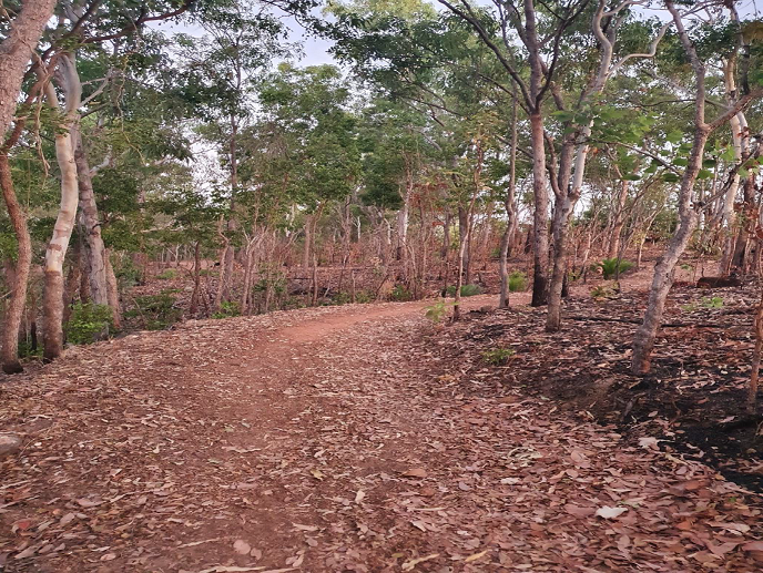
If you would like to know more or get involved please contact This email address is being protected from spambots. You need JavaScript enabled to view it.
Download the Mitchell Botanical Gardens suggestions from here: Mitchell Botanical Gardens Suggestions.pdf

Posted in Current Campaigns
Sun Newspapers 28.11.2017
... Council has given in-principle support to the Chief Minister's announcement for a 450-bay underground carpark to be built on the Parliament House Greens. The investment will see the existing carparks at Supremme Court, Chan Building and the Cenotaph on the Esplanade replaced with green, open spaces. We are working towards a shared goal to transform the city centre into a greener, cooler walkable city and we welcome opportunities and discussions to extend green spavces for the community to enjoy leisurely activities. ...
Posted in Blog & Opinion
Community Survey 2020
PLan - the Planning Action Network Inc is a volunteer community group working for better urban and rural planning in the Northern Territory.
We value your opinion on matters that concern all Territorians.
Take the survey online here: https://actionnetwork.org/forms/survey-2020
Download the survey from here: https://planinc.org.au/images/documents/Community_Survey_2020_v2.pdf
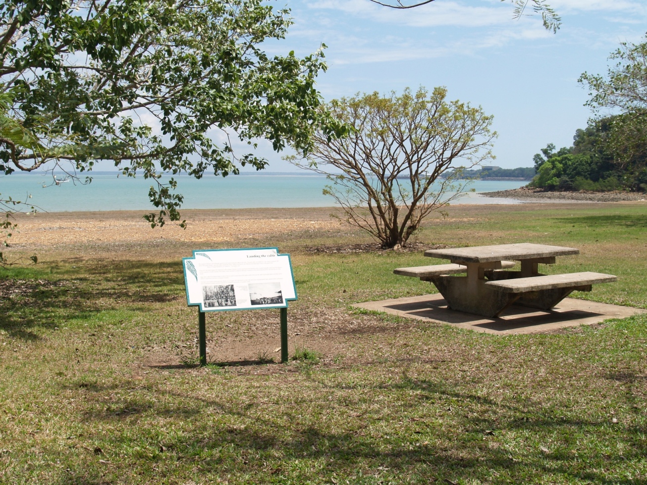
Posted in Community Alert
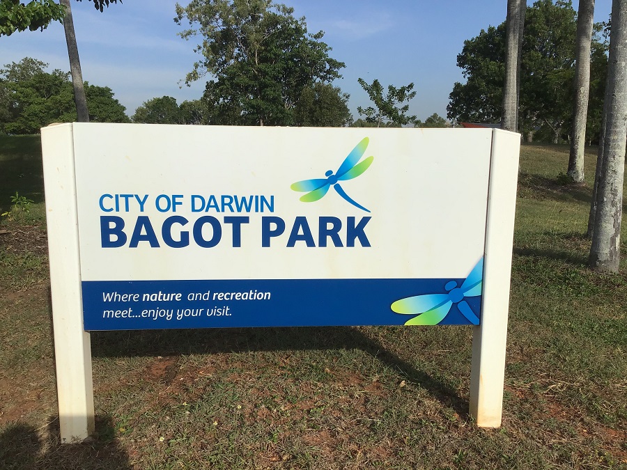
Bagot Park Sign
Car Park Trees at risk of being removed.
Posted in Uncategorised
UPDATE
Read the Bagot Park For Now and Future Generations document prepared by community members.
City of Darwin hands back $8m at request of CM.
"On the 21 July 2020, the Lord Mayor received correspondence from the Chief Minister of the Northern Territory, stating that “as it is now clear that both the cycling community and local residents are very strongly opposed to the velodrome redevelopment project in its current form” and is requesting COD return an amount of $8M from the funding agreement for the Velodrome project"
Community interferes with COD project!
"Interference in the project from persons outside of COD and the NTG has resulted in a lack of clarity in the project deliverables under the funding agreement by both the Friend of Bagot Park and the Cycling community resulting in diametrically opposed views as to what the Confidential Ordinary Council Meeting Agenda 28 July 2020 Item 26.4 Page 7 project outcomes were to be. There is a risk that COD’s reputation as an organisation that is able to deliver projects that meet with community objectives may be tarnished as a result of this interference."
Our empasis above.
Read the report here: confidential_late_agenda_28_july_ordinary_council_meeting
Friends of Bagot Park are opposed to the NT Government and Darwin City Council’s plan to construct a Cycling Precinct on all of the existing vacant parkland in our suburban-based recreational park. The NT Government has funded the project at a cost $10.5m.
We believe that the park should be a great place to picnic, celebrate family milestones, get active and attend an event, a place that everyone can share and enjoy. Many residents purchased their homes in this area because they were drawn to the appeal of the open parkland space. We all need a space to take a breath.
Residents are confused, angry, frustrated and disappointed with not being involved in any part of the decision-making and planning process and want the park to remain as open parkland.
TAKE ACTION
We urge you to take action. Save your Bagot Park now and for future generations. Saving Bagot Park includes:
- Locating the Velodrome and Cycle Precinct elsewhere
- Rezoning all vacant land as Public Open Space
- Developing a “Whole of Bagot Park Master Plan”
- Resolving traffic and parking problems
- Beautifying the park with mass planting of trees native to the area
- Repairing and revamping verges with attractive landscaping
- Engaging with Millner residents on future developments
Begin by signing the petition here: Save Your Bagot Park petition.
Next write to the politicians using this on-line email Page: https://actionnetwork.org/letters/save-your-bagot-park?source=direct_link&
Call or visit your electorate representative. Find out who your representative is here: NT MLA Contact Details and here
City of Darwin Aldermen Contacts here:
Residents are opposed to the original concept plan that includes:
- Rebuilt velodrome
- Bike Skills flat track with jumps, ranging from 4m wide to 8m wide
- Criterium (race) asphalt track, 3-metres wide with connection points to pedestrian paths, and
- 2-metre wide Pump Track with continuous loops and mounds.
Despite consistent efforts to gain information from the City of Darwin, we have not received formal acknowledgement or details of the plans other than the original drawing of the concept plan.
The main reasons for opposition to this project includes:
- Neither a Feasibility Study nor a Master Plan for the park in its entirety has been developed
- Traffic, parking and safety issues remain unresolved
- Duplication of infrastructure for two major sporting organizations
- Significant reduction of the entire open parkland
- Little or no engagement with Millner residents, and
- Bagot Park is an inappropriate park to be developed as a Cycling Precinct
The City of Darwin Council’s Functions and Objectives include providing for the interests and well-being of individuals and groups within the council area and to act in the best interests of the community as a whole. The NT Government also has a responsibility to respect the needs and aspirations of the constituents of the Millner community.
We need the NT Government and the City of Darwin to be accountable to their citizens.
BACKGROUND
Bagot Park is a large recreational park in Millner and provides an escape for the small pocket of homes bordered by Bagot Road and McMillans Road (major highways), Sabine Road and the service road of Old McMillans Road. Bagot Park is home to a local soccer club which uses the park on a daily basis and an existing velodrome in a poor state of repair.
Millner is an established, small suburb with many old Darwin residents, located 10 km from the city.
Adjacent to the football ovals and velodrome is open parkland which provides a buffer zone from noise and pollution from motor vehicles on McMillans Road, an arterial road leading to and from Darwin city. Part of this parkland is zoned as OR (Organized Recreation) and part PS (Public Open Space). Bagot Park is recognized and admired for its open space and shady trees which is reflective of its entry sign tagged, “Where nature and recreation meet”. People use the park as a place to wander and reflect, exercise, walk with their families, exercise their dog/s and enjoy the birdlife.
ZONING
The NT Planning Act states that development in Zone PS should be limited to that which has minimal adverse impact (if any) on adjoining or nearby property. Development of land in Zone OR is to be limited to that which is consistent with the recreational opportunities of the land. We believe that the proposed Cycling Precinct development of Bagot Park will have a major adverse impact on the adjacent residential area.
Old McMillans Road is a narrow service road and traffic congestion, parking and safety are major problems. Noise, pollution, night car lights, loss of park space, loss of huge old trees are other important but unresolved concerns. The unplanned sites for additional and duplicated buildings add to a visual mishmash of buildings within the same park. (Ref: Objection to the Proposal of the Development of a Bicycle Precinct at Bagot Park)
The zoning of the parkland needs to be changed to PS – Public Open Space where the land use is to provide areas for recreational activity for public use and enjoyment and which has minimal adverse impact on adjoining or nearby property.
The quality of our neighbourhoods, towns and cities has a significant impact on our daily lives. The open spaces of Bagot Park provide quality to the Millner neighbourhood.
FUNDING
NT Government has funded the project and is working in partnership with the City of Darwin who will deliver the project. In February 2020, the City of Darwin appointed a consultancy engineering firm, Cardno as Project Manager.
CONSULTATION
Pending a community consultation, the City of Darwin Council agreed in principle to the Cycling Precinct and, in April 2019, conducted a community survey based on the original concept plan. The survey comprised of yes/no questions with some room for comment. Friends of Bagot Park submitted a written and detailed submission outlining their reasons for their objections to the proposed cycling precinct.
Friends of Bagot Park analysed the survey results which indicated a heavy skew from cyclists’ supporting the cycling precinct. The result was reflective of a direct correlation with the larger number of cyclists’ respondents who used the velodrome, compared to the small population of people who live in the area. The City of Darwin reported an overwhelming response in favour of the Cycling Precinct. Further correspondence was submitted to the City of Darwin detailing the flaws and inaccuracies in the Consultation Outcomes Report. The majority of residents’ responses indicated that they did not want the Cycling Precinct to go ahead.
26th February 2020 Scott Waters, CEO, City of Darwin, email to Friends of Bagot Park: “Council officers are currently working with the procured consultant engineering firm to deliver detailed design as per the consultation that occurred last year. Once this has been completed stakeholder engagement will occur.”
Although both representatives of the NT Government and Council advised they would engage with the Friends of Bagot Park, apart from the original community consultation, neither the Friends of Bagot Park nor residents have been offered the opportunity to engage and discuss any plans involving the park development. We were only briefed on the Consultation Outcomes,
PLANNING PROGRESS TO DATE (as we know it)
Since the early planning stages and the original concept plan on which the community survey was based, there appears to have been many changes to the proposed project. Despite Friends of Bagot Park ongoing questions and requests for more information, the residents of Millner still do not know what is to be included in Velodrome Project.
Infrastructure for the velodrome including an additional car park, an amenities block, grandstand, storage area and clubrooms are rumoured as future developments and, although not confirmed, the plans for the pump track and criterium track are part of the cycling precinct design and may also be included in the cycling precinct.
TRAFFIC AND PARKING PROBLEMS
Bagot Park is one of the home grounds for football in Darwin and is used on a daily basis. During the season, on competition days, the overflow from up to 400+ vehicles park wherever they can find space as the existing car park is too small.
Traffic congestion occurs on all neighbouring roads. Additional vehicles using the cycling precinct will exacerbate the traffic and parking problems. Residents do not believe that the Traffic Study Report accurately reflects several of the traffic and parking issues at Bagot Park. A discussion with residents about these issues would have gone a long way to a better understanding and reporting of them.
The identified need for additional parking would result in more parkland allocated to construct another car park. Construction of oval lighting for night-time training and football matches is in progress, intensifying the constant use of local roads. A concept plan has been presented to the City of Darwin showing an upgrade of the current car park with all the shade trees removed to create maximum parking places. Removal of trees to develop a hot bitumen car park adjacent to residences is unacceptable planning.
10th December 2019 Traffic Study and Road Safety Audit in Response to Velodrome Precinct Proposals: Author: Executive Manager Technical Service: Ordinary Council Meeting “According to the Capital Grant Funding Agreement (Agreement) for the design and construction of the Velodrome upgrades and lighting, the scope includes the construction of a new velodrome, bike skills area, club and facilities, storage, car parking and landscaping.
“This assessment also confirmed that the car parking expected as a result of the proposed new developments in the area would exceed the capacity of the proposed new Old McMillans Road car park”
“All of these roads are capable of accommodating to 3,000 vehicles per day so the current levels of traffic are comfortably accommodated”
“There is therefore a potential parking shortfall on-site to the order of 26 bays. However, there is potential space on site to provide an additional estimated 30 to 40 angle parking bays along the future velodrome track which would result in the overall parking scheme being able to accommodate the total predicted parking generation.”
MASTER PLAN
For a park development of this magnitude and diversity, at a cost of almost $12m, there must be a Master Plan for Bagot Park in its entirety. The development of a Master Plan should involve all stakeholders including interested groups, representatives from the wider community, Friends of Bagot Park, sporting groups and other relevant stakeholders. There has been no Master Plan developed for Bagot Park despite the City of Darwin recognising the need for Master Plans in its Sports Field Plan 2016-2026, which cites under the heading of “Functionality Enhancements” p9:
- “Develop Master Plans for individual sporting ovals”, and
- “Ensure Master Plans consider opportunities to improve the functionality of each site.”
ADDITIONAL INFRASTRUCTURE
There are plans for significant additional infrastructure for Bagot Park. Current buildings include a public toilet and a kiosk for the Football Club. Plans are underway for the sport of football to construct, at Bagot Park, a “club house” with male and female change rooms, operations room, referees change room/storage area with confirmed Commonwealth funding.
Football NT’s planned infrastructure combined with the Velodrome plans for an amenities block, storeroom, an additional car park and a possibly a future clubroom and grandstand means unnecessary duplication of buildings within the park and does not reflect good planning. A Master Plan would have been in alignment with best practice and considered these infrastructure requirements along with any plans for future development of the park thus avoiding unnecessary duplication and ongoing frustration and dissatisfaction with ad hoc and poor planning.
CONCLUSION
BAGOT PARK IS AT RISK!
Open parkland will be filled with a maze of ugly 2 to 8-metre wide gravel and black asphalt cycle tracks. An additional car park and duplicated infrastructure will absorb our treasured park and become a blight on our open space.
Residents and members of the local community will no longer be able to enjoy the park as previously enjoyed.
The new velodrome with all the additional facilities and cycling elements belongs elsewhere.
Please help us to save Bagot Park now and for the generations to come by signing our petition "Save Your Bagot Park"
FOOTNOTES
NOTE Footnote links to be appended over next few days, please return to read
The following documents have been used to support our claims:
1. Velodrome Precinct Proposal – Community Consultation Fact Sheet City of Darwin
2. Objection to the Proposal of the Development of a Bicycle Precinct at Bagot Park
3. Response to Consultation Outcomes – Friends of Bagot Park: Letter to City of Darwin
4. Questions from Friends of Bagot Park: City of Darwin’s Responses
5. Traffic Study Report
6. Friends of Bagot Park Media Release
7. Friends of Bagot Park - Wants and Needs: Provided to Minister Lawler on Request
8. Letter to the Editor - NT News: Millner Resident
9. City of Darwin Sports field plan 2016-2026
10. Friends of Bagot park – Our position – given to Joel Bowden, MLA for Johnston Electorate
11. Photos of Parking
12. Photos of Bagot Park
13. NT Planning Scheme – Index of Zones
14. Bagot Park Action Taken Timeline
Posted in Current Campaigns
There is now a Save Lee Point Website. Please see here: https://saveleepoint.org.au/
It’s your Lee Point
This campaign is about having land at Lee Point rezoned to encourage the efficient use of land, infrastructure and services for Darwin residents.
The land at Lee Point zoned as Future Development is next to biologically rich Casuarina Coastal Reserve (CCR) encompassing vulnerable/endangered wildlife, plants, and has internationally significant shorebird sites. CCR has over 1M visits each year and is increasing. This valuable asset produces revenue from ecotourism and could be expanded.
Rezoning the Lee Point land to Conservation means future defence housing would need to be located elsewhere. If for instance, Australian Defence Force personnel were located at Northcrest they would be much closer to work, have more frequent public transport, and not be exposed to biting insects or sewage pond odours. Taxpayers would find this more affordable because a lot of the infrastructure and services are already set up.
It’s your Lee Point – it’s your choice.
TO BE UPDATED - DRAFT FOR DISCUSSION PURPOSES - 6 July 2020
Improving the cost benefit of future defence housing in Darwin
Preliminary Assessment
Note: this is a draft paper and subject to change. It has been released early to assist with the “It’s your Lee Point” awareness campaign.
6 July 2020

Prepared by Ian Redmond and Gayle Laidlaw
(Darwin residents since the 1980’s)
EXECUTIVE SUMMARY
This preliminary assessment is in response to the proposed development of 800 houses (for 3000 people) by Defence Housing Australia (DHA) at Lee Point on lot 4873 and 9370. The assessment looks at the merits of locating future Australian Defence Force (ADF) personnel at Northcrest (near Berrimah Farm) and future rezoning of lots 4873 and 9370.
The scope of this assessment is limited in that it only considers Northcrest as an alternative site for housing future ADF personnel, and does not evaluate headworks cost, list relevant services for either Northcrest or Lee Point, eg education, health, recreation, retail, entertainment, which affect lifestyle, or consider different growth scenarios. Further work would be needed to better understand the costs and social benefits prior to engaging with stakeholders for both sites.
However, preliminary findings from the assessment indicate that future ADF personnel would be better and more affordably housed at Northcrest due to its central location, closeness to the major defence sites.
Similarly, there would also appear to be significant benefits in revisiting the best use of the Lee Point land having regard to the changes that have occurred since the use of this land was last reviewed in 2005.
Rezoning of the Lee Point lots 4873 and 9370 to Conservation (or similar use) provides a potential opportunity to reduce development costs (for the taxpayer), grow ecotourism in Darwin, and significantly reduce the environmental impact that would have come from the DHA’s proposed Lee Point housing development.
Background
Lee Point has played a role in a number of important historic events, such as the bombing of Darwin, the defence of Australia during World War Two and the Indonesian confrontation of the early 1960s. A radar station was located on lot 4873 (see map at Attachment B) until the early 2000s. The land is no longer used for military purposes.
Defence Housing Australia (DHA) is proposing to build 800 houses (for 3000 people) at Lee Point, refer to Appendix (Ref 1). The houses are to be built on lot 4873, next to Casuarina Coastal Reserve (CCR), and lot 9370. Based on the Notice of Intent prepared for DHA in 2015, (Ref 2);
- Lot 4873, also called 2CRU (Lyons North) is owned by the Commonwealth, and
- Lot 9370, also called Muirhead North is owned by the NT Government.
Lee Point lots 4873 and 9370 were included in the NT Planning Scheme in 2015 (Ref 3). A development application for lot 4873 was lodged by DHA to the NT Government in November 2017. It is not known how many houses are to be reserved for ADF members.
DHA is wholly owned by the Australian Government. Its main function is providing housing and housing-related services to members of the Australian Defence Force (ADF) and their families. (Ref 4).
Northcrest (168 ha), refer map below, is owned by Halikos Group, a Territory owned and operated business. Halikos Group has planned for 2000 houses plus a commercial development at Northcrest. The first land release (114 lots) commenced in March 2017 (Ref 5) and about 100 lots have been sold (5% of planned housing lots).
Darwin’s major defence sites (Ref 6), shown here in grey, provides the work place for most ADF personnel.
Sustainability
Sustainability is considered from three perspectives:
- Social;
- Environmental; and
- Economic
for the Lee Point Development (LP) and Northcrest Development with defence housing (NC).
SOCIAL
NC and LP are less than 10km away from a major shopping centre, school, medical centre, major sporting complexes, boat ramp, and nature reserve. However, NC offers a greater choice of services eg restaurants, shopping and entertainment due to its central location.
NC’s central location would make it easier for ADF personnel to:
- cycle to work (cycling to the major defence sites from NC was assessed as easy to moderate, and from LP as moderate to hard, refer Attachment A;
- use public transport (frequent – and more cost effective - bus services are already available); and
- visit the Darwin CBD and Palmerston CBD.
LP provides walking access to a beach in Casuarina Coastal Reserve (CCR). However, for LP; “The NT EPA identified a potential conflict of siting an urban development near an existing wastewater treatment facility, with potential for offensive odours to impact on future residents’ lifestyle and amenity. Similarly, potential health impacts to residents from proximity to breeding habitat for biting insects is also of concern.” (Ref 7, Sect Summary and Recommendations).
ENVIRONMENTAL
NC has minimal impact because the land was previously used for farming.
LP has a significant environmental impact. The inevitable introduction of more cats and dogs (predators) in the Lee Point region will threaten vulnerable or endangered wildlife species in the Lee Point area, such as migratory shorebirds, marine turtles, and Black Footed Tree Rat. Clearing of land will also threaten certain native endangered flora, and reduce wildlife numbers generally, refer Attachment B.
ECONOMIC
Economic sustainability relies somewhat on eliminating spending where it is not needed.
ABC News reported in February 2019 that Darwin ADF numbers had fallen by more than 25% since 2010 (Ref 8) and in March 2019 that Darwin’s 2018 population had declined by 0.2% (Ref 9). The issue of housing oversupply needs to be fully considered, particularly in light of the associated high cost of public infrastructure that is required for housing developments.
NC is partly developed with some headworks in place. It is expected to have lower costs (per lot) than LP due to its central location. However, these costs are largely unknown.
Attachment C lists potential costs and a possible use for the LP land (if it is rezoned).
Rezoning issues
Land Use Plans for any region are dynamic (not static), and should respond to changing circumstances: Darwin Regional Land Use Plan – Plan Purpose, 2015. (Ref 10)
Much has changed since the Lee Point Area Plan was incorporated into the NT Planning Scheme in 2015 (Ref 3). Darwin’s ADF personnel numbers have fallen significantly in the last ten years (Ref 6), and people are increasingly concerned about the environment, including the rate of greenhouse gas emissions and loss of biodiversity.
Risks of not rezoning the Lee Point land
CCR has internationally significant shorebird sites. The risk of not rezoning Lee Point is that CCR’s growing reputation could be diminished and residents find the Casuarina/Lee Point area less attractive to live in. Rezoning the Lee Point land supports the Australian Government’s Smart City Plan (ref 11, smart policy), and may lead to future funding opportunities with the Australian Government, refer to Attachment D.
Risks in rezoning the Lee Point land
The risk to the Australian Government of it not being able to use the Lee Point land (if it was rezoned and retitled), is non-existent because it has the power to override any Act of the Territory at any time. The loss of 800 house lots at Lee Point is not considered significant given the recent downturn in Darwin’s economy, and the potential to provide 2000 house lots at NC.
DHA has invested time and resources in planning a housing/commercial development at Lee Point which be lost if the land is rezoned.
Summary and Recommendations
Darwin needs long term jobs to sustain its population and improve its economy. The housing development at Northcrest (NC) appears to be more sustainable than at Lee Point lots 4873 and 9370 (LP) in all aspects; social, environmental and economic, due to its central location and closeness to the major defence sites. LP would be better rezoned to Conservation (or similar use) to promote ecotourism. However, these findings should be confirmed prior to engaging with stakeholders on the sites. The following work is recommended to confirm the findings:
- Evaluate the cost of headworks (capital and recurrent) per lot at LP, NC and another site (if suitable). Indicative costs to meet the NT EPA Assessment Report 88 requirements at LP are to be included.
- Assess the social benefits of living at LP, NC and another site (if suitable), from known services in the area, and list these services. Provide comment on what locations might best attract and retain ADF personnel.
- Discuss various future growth scenarios for Darwin in relation to housing supply.
- Comment on the environmental impact at LP versus NC, including greenhouse emissions.
ATTACHMENT A
Indicative travel times to Darwin’s major defence sites
The travel tables below were generated from Google Maps (Directions), and are provided here for strategic planning purposes only.
TRAVEL BY CAR
|
Car Travel
|
Darwin CBD Post Office
|
Larrakeyah
Barracks
|
RAAF Base
|
Defence Establishment Berrimah
|
Robertson Barracks
|
Palmerston CBD Post Office
|
|
Lee Point
|
20 min
(17.1km)
|
22 min
(17.7km)
|
15 min
(13.1km)
|
16 min
(12.2km)
|
19 min
(16.9km)
|
22 min
(21 km)
|
|
Northcrest
|
13 min
(12.6km)
|
16 min
(14.2km)
|
9 min
(8.5km)
|
6 min
(3.4km)
|
12 min
(9.6km)
|
11 min
(10km)
|
|
Difference
|
7 min
(4.5km)
|
6 min
(3.5km)
|
6 min
(4.6km)
|
10 min
(8.8km)
|
7 min
(7.3km)
|
11 min
(11km)
|
Notes:
- Car travel times will vary according to traffic, ie. time of day and year.
- Car travel from Lee Point to Darwin’s major defence sites ranges from;
In time: 15-22 min and is 6-10 min longer than from Northcrest.
In distance: 12.2 - 14.2km which is 3-9 km further in distance than from Northcrest.
TRAVEL BY BIKE
|
Bike Travel
|
Darwin CBD Post Office
|
Larrakeyah
Barracks
|
RAAF Base
|
Defence Establishment Berrimah
|
Robertson Barracks
|
Palmerston CBD Post Office
|
|
Lee Point
|
54 min
(17.9km)
|
56 min
(18.6km)
|
41 min
(13.9km)
|
42 min
(12.8km)
|
50 min
(17.1km)
|
67 min
(22.3 km)
|
|
Northcrest
|
41 min
(12.6km)
|
45 min
(13.5km)
|
26 min
(8.5km)
|
9 min
(3.1km)
|
29 min
(9.6km)
|
30 min
(9.5km)
|
|
Difference
|
13 min
(5.3km)
|
11 min
(5.1km)
|
15 min
(5.4km)
|
33 min
(9.7km)
|
21 min
(7.5km)
|
37 min
(12.8km)
|
Notes:
- Google Maps tends to select bike tracks which can increase distance compared to car travel.
- Bike travel from Lee Point to Darwin’s major defence sites ranges from;
In time: 41-56 min and is 11-33 min longer than Northcrest
In distance: 12.8 - 18.6km and is 5-10 km further in distance than from Northcrest.
- Cycle to Work website considers cycling difficulty; 0-8kms as easy, 10-16kms as moderate, 18-24kms as hard.
Findings
Car travel from Lee Point to the major defence sites is significantly longer in time (6-10mins) and longer in distance (3-9km) than from Northcrest. Cycling to the major defence sites from Northcrest is considered to be easy to moderate, and from Lee Point moderate to hard. It is likely that more ADF personnel would cycle to work if they lived at Northcrest.
ATTACHMENT B
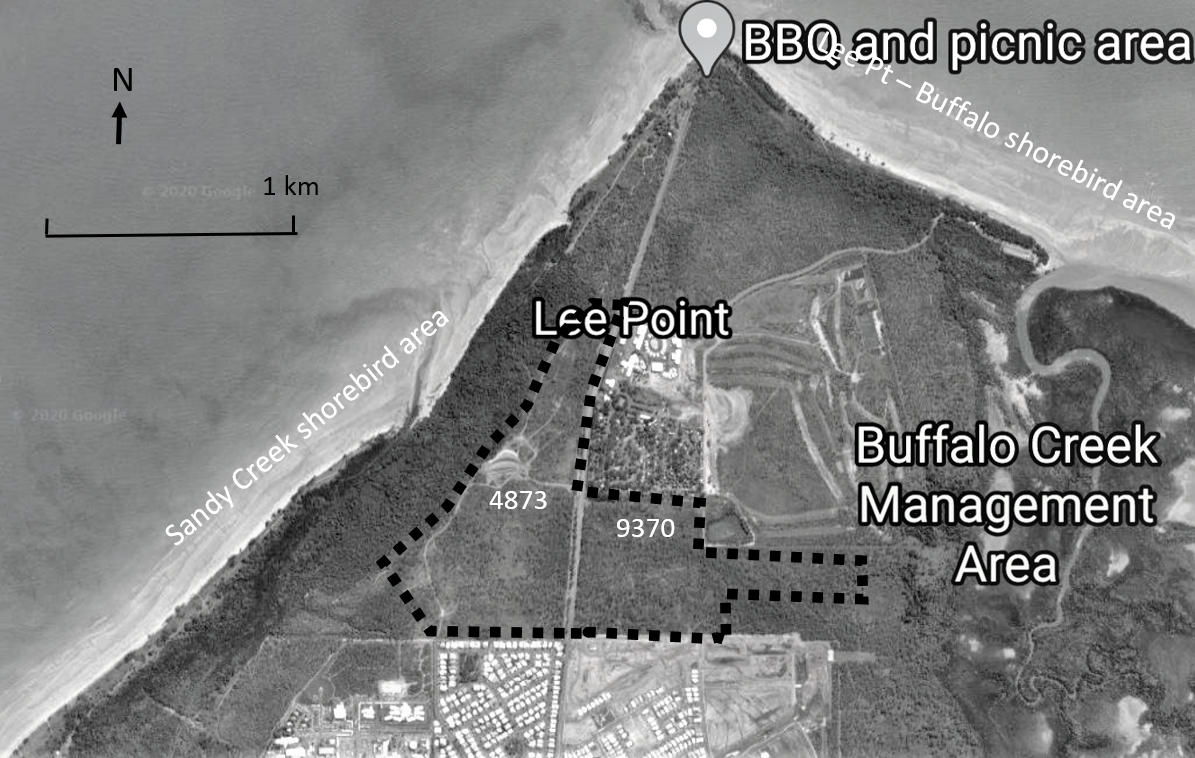
Lee Point Development
Dashed line shows the area to be cleared for housing and commercial purposes within Lots 4873 & 9370, it does not show actual lot boundaries. CCR is to west and north of this area.
Casuarina Coastal Reserve and protection of wildlife
The NT Government and City of Darwin has been running programs to protect wildlife from cats and dogs. With the proposed 800 houses (and more cats and dogs), protection of wildlife in CCR will become more difficult.
The Black Footed Tree Rat is classed as vulnerable in the NT and endangered nationally. Its numbers have fallen sharply in the NT since 2002 (Ref 12). Possible reasons for the decline include loss of suitable habitat and predation by feral cats. In 2017, it was photographed in Lot 9370 as part of the EIS process. The habitat shown on the left in the photo is considered to be good habitat for this species (Ref 13, Appendix M).
|
 Photo of Lee Point Road (looking north), Lot 4873 on the left. Photo of Lee Point Road (looking north), Lot 4873 on the left.
|
 Black Footed Tree Rat (Wikipedia) Black Footed Tree Rat (Wikipedia)
|
ATTACHMENT C
Headworks cost and future land development costs
The headworks cost at LP (for a population of 3000 people) could exceed $20M and needs to be better understood. Some headwork upgrades could have been carried out with the previous development of Lyons and Muirhead.
It’s likely that LP will require a new water storage facility, sewage pump stations, HV feeder, road and drainage works. In 2012, the City of Darwin estimated developer contribution cost for the roadworks from Muirhead to Lee Point would cost $4.1M. (Ref 14). There are possible upgrades to sewage treatment ponds and the electrical substation. The NT EPA (Ref 7, Recommendations) places stringent conditions on LP to reduce the significant environmental impact. It includes implementing a shorebird monitoring program, protecting marine turtles, stormwater discharge to tidal areas, cautionary notes to property buyers about biting insects, plus other requirements. This will increase costs at LP. There is increased car and public bus travel costs at LP compared to NC. None of these costs have been evaluated, nor has the greenhouse gas emissions (from increased car travel).
The headworks cost at NC (for a population of 7000) needs to be better understood. Some headworks have been carried out for NC as part of the first stage. It is likely that NC will have lower headworks cost per lot than LP due to its central location.
Ecotourism at Lee Point (to be updated)
One of the fastest‐growing tourism sectors is ecotourism (Ref 15). Casuarina Coastal Reserve (CCR) has over 1M visits a year and this number is increasing. A possible use for the Lee Point land (next to CCR) is ecotourism. It could involve walks showing wild food plants, aspects of aboriginal culture, bike trails, and defence history. While the area has some attractive woodland and a small rainforest, parts of it will need to be cleaned up (rubbish removed) and revegetated.
Larrakia Nation are the traditional owners of Lee Point. Section still to be drafted?????
Mountain bikers regularly use the LP area, and Darwin Off Road Cyclists (DORC) are already promoting mountain bike riding at Lee Point. There is currently a concept for a coastal trail (walking/cycling) from the CBD to Lee Point. The coastal trail, some of it already constructed, would pass by areas of interest such as the East Point Military museum. Lot 4873 could provide another “area of interest” on the coastal trail. Accommodation is available at the nearby Lee Point Village Resort.
For defence history, it would mean obtaining and displaying additional defence relics as many of the relics have been removed. Based on the NT EPA (Ref 7, Sect 5.1.2), lot 4873 contains the remains of a missile launching facility and explosives store, and remnants of anti-aircraft battery sites. Lot 9370 has the remains of a defensive gun pit.
ATTACHMENT D
Zoning of Lee Point land to attract investment (to be updated)
NT GOVERNMENT
In 2015, the NT Government released its Darwin Regional Land Use Plan (Ref 10) which included:
Key residential objectives:
- Integrate new and existing residential development to maintain character and create a cohesive society that meets the diverse needs and aspirations of all sectors of the community.
- Ensure sustainable development by encouraging:
○ the efficient use of land, water, energy and other resources
○ accessible and efficient public transport to reduce transport demands
○ cost effective provision and efficient utilisation of infrastructure and services
○ development that is consistent with the community’s economic, social, cultural and environmental values
○ the creation of character and identity
○ opportunities for community initiatives that support happier, healthier and inclusive communities
AUSTRALIAN GOVERNMENT
In 2016, the Australian Government committed to the Smart Cities Plan (Ref 11). The Smart Cities Plan provides a platform for long term investment and coordinated planning to help Australian cities reach their full potential.
In essence, the NT key residential objectives (see above) are not inconsistent with the Australian Government’s Smart City Plan. Issues such as the efficient use of land, accessible and efficient public transport, cost effective provision and efficient utilisation of infrastructure and services are common to both.
ZONING OF LEE POINT LAND
Rezoning the Lee Point land to Conservation (or similar use) encourages housing development at NC, an action which promotes the efficient use of land, infrastructure and services, and in turn supports the Smart Cities Plan. Developing in accordance with the Smart City Plan may help obtain future Australian Government funding under the Smart City Plan: City Deals initiative.
The NT Government and Australian government signed a Memorandum of Understanding in 2017 to work cooperatively together on City Deals. The first Darwin City deal was signed in 2018 and an implementation plan was produced on November 2019.
APPENDIX
Bibliography
Ref Title
- Defence Housing Australia website: https://www.dha.gov.au/development/residential/lee-point
- EcOz Environmental Consultants: Lee Point Master-planned Urban Development: Notice of Intent, prepared for Defence Housing Australia, June 2015 https://ntepa.nt.gov.au/__data/assets/pdf_file/0007/287602/noi_lee_point.pdf
- NT Government: Planning Scheme Amendment No 369, Aug 2015: https://nt.gov.au/__data/assets/pdf_file/0009/205884/amendment-369.pdf
- Australian Government Department of Finance: Defence Housing Australia: https://www.finance.gov.au/business/government-business-enterprises/defence-housing-australia-dha
- Halikos website: https://northcrest.com.au/faqs/
- NT Department of Treasury and Finance: NT Defence: https://nteconomy.nt.gov.au/industry-analysis/defence
- NT EPA: Assessment Report 88, Oct 2018 – refer to NT EPA website: https://ntepa.nt.gov.au/__data/assets/pdf_file/0009/593703/assessment_report_lee_point_urban_dev.PDF
- ABC News, Feb 2019: https://www.abc.net.au/news/2019-02-17/defence-numbers-down-annually-since-2010-darwin/10794850
- ABC News, March 2019: https://www.abc.net.au/news/2019-03-27/population-falls-in-darwin-northern-territory-abs-data/10946200
- NT Government: Darwin Regional Land Use Plan, 2015https://nt.gov.au/__data/assets/pdf_file/0019/240247/darwin-regional-land-use-plan-2015.pdf
- Australian Government: Smart Cities Plan https://www.infrastructure.gov.au/cities/smart-cities/plan/index.aspx
- NT Government: Black Footed Tree Rat, 2012: https://nt.gov.au/__data/assets/pdf_file/0018/205515/black-footet-tree-rat.pdf
- ECoZ Environmental Consultants: Black-footed Tree-rat Survey Report Lee Point Master-planned Urban Development EIS, June 2017: https://ntepa.nt.gov.au/__data/assets/pdf_file/0011/593687/supp_draft_eis_lee_point_urban_dev_appendixM_blackfooted_tree_rat_report.PDF 3
- City of Darwin: Developer Contribution Plan for Roadwork, Lee Point Road - Vanderlin Drive to Lee Point Reserve, November 2012: https://www.darwin.nt.gov.au/sites/default/files/publications/attachments/lee_point_road_roadwork_developer_contribution_plan.pdf
- Tracie McKinney: Ecotourism, November 2018: https://onlinelibrary.wiley.com/doi/abs/10.1002/9781118584538.ieba0149
Posted in Current Campaigns
What is the role of the City of Darwin?
What is the role of the Lord Mayor?
There are three layers of government in Australia.
"Roads, Rates and Rubbish".
What does the council do?
What is the mission and objectives of the City of Darwin?
What is the role of the Darwin Waterfront Corporation?
What is the role of Community groups?
Posted in Community Alert
Like a shell and pea switch game the practice of selling Community Purpose land to developers hides the obvious outcome.
Without confirming that the Community wants the asset to be relinquished government sells land like the top of the escarpment over the Botanical Gardens.
Then all the purchasing developer has to do is apply for a rezone and presto Community Asset is gone and inappropriate development is on the go.
Posted in Community Alert
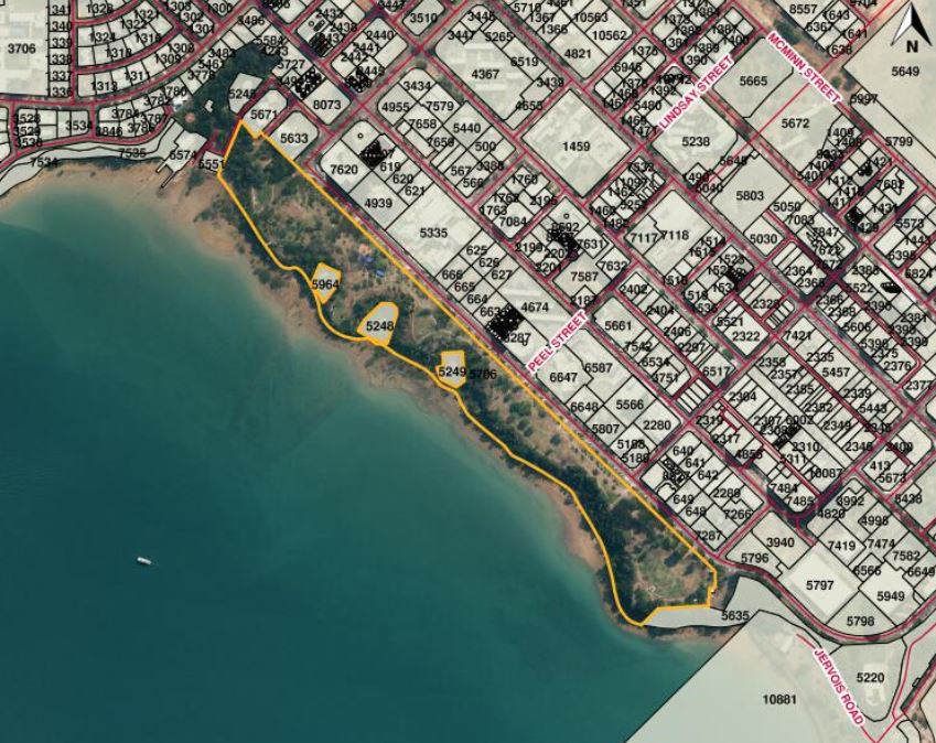
November 2022,
https://planinc.org.au/18-government-a-council-consultations/313-report-on-consultation-on-the-greening-of-the-esplanade-cenotaph-presented-at-the-ordinary-council-meeting-of-25-october-2022.html
It seems to us that the City of Darwin (Darwin City Council) has veered off the rails in a big way. Many decisions that affect the assets of the City of Darwin are being taken in secret. The principal stakeholders, the rate payers of Darwin, are the last to hear of the latest asset disposal. In our opinion this is in direct contravention of the City of Darwin's mandate.
We wish to remind Council of their functions and objectives (including to provide services and facilities for the benefit of its area, residents and visitors, to provide for the interests and well-being of individuals and groups within the council area, and to act in the best interests of the community as a whole) when they are deciding how to proceed.
Quotes:
28 October 2019 COD in response to a PLan enquiry - Council is not considering any matters in relation to the RSL at this upcoming ordinary meeting. Council is considering a recommendation for Stage 1 of the Cenotaph Renewal, as part of funding received from the Australian Government. Can you please provide more detail in relation to your questions below, particularly when information was received and from whom?
18 February 2020 - The Darwin Film Society (DFS) is writing to you to outline serious concerns regarding proposed development in the vicinity of the cinema. A development of this size and nature, in the proposed location will cause severe disruption to the cinema. The City of Darwin will lose a major attraction for tourists and locals if the Deckchair Cinema is forced to close. Jeff Coulter,
Chair of the Darwin Film Society
13 May 2020 - NT Independent quotes RSL President Steve Gloster said Darwin RSL was finalising a proposal to build a three-level venue on the site of the Cenotaph carpark at the edge of the Esplanade, featuring an underground carpark, ground-level café and a club area located on the top floor.
13 May 2020 - Darwin Mayor Kon Vatskalis has suggested relocating might be the best option for the iconic outdoor movie venue.
On the ABC at 7.30am+ on 25th May 2020, Chief Minister Michael Gunner said on air that the Esplanade was really not the right place for the RSL. His expectation was that a cool green open space would be established to allow for the large numbers who have been attending the Anzac Day events. This was as agreed previously.
Take Action
Write to the politicians using this online email page: https://actionnetwork.org/letters/no-development-on-the-esplanade-2?source=direct_link& direct contact is vital.
We urge to you to save the Deckchair Cinema. Begin by signing the petition here: https://www.change.org/p/the-northern-territoty-government-protect-the-deckchair-cinema-by-greening-the-cenotaph-car-park
Call or visit your representative. Also who is your representative? Found out here NT MLA Contact Details and here City of Darwin Alderman Contacts .
More details:
The Public Esplanade was established by George Goyder in 1869, at the time of the first actual Survey of land laying out the Darwin plan (then named Palmerston).
It provides a large area of open space between the sea and the first line of lots for built development on the actual Darwin plateau above the escarpment from the sea.
In English Speaking communities throughout the world, it has been the custom and rule in planning to set aside such a green area for the free use and enjoyment of the ordinary people. Our Esplanade is consistent with this civic custom and should remain that way.
The Public Esplanade provides not just open space for general recreation, but also panoramic views of all angles of Darwin Harbour. The adjourning street, as in many Australian cities, is named The Esplanade.
In 1920/1, the importance and significance of this principle was reinforced when the Governor General issued a national proclamation, an original of which is in the National Archives, Canberra. It provides that there be no building on the Darwin Esplanade.
Our understanding of the roll of local government in holding open spaces not privately owned, is a custodial one – (held in trust). It is strictly that councils manage these lands on behalf of the public. They are not financial assets of each relevant council, to be leased to private entities, and certainly not sold, or ever alienated from the public.
People should be outraged that anyone should even suggest that such lands should be ‘commercially’ developed as ‘assets’ by council, as the current Lord Mayor Kon Vatskalis has done through the NT News recently. These are public assets for recreation in an entirely different sense and should stay public assets. Availability of areas of such public assets should be increasing as the Darwin population grows, and not be reduced.
There should be no building on the Public Esplanade.
The Darwin Cenotaph is not a building, but a Memorial to those men and women to whom we owe our own personal freedom. It is a very public place in a suitable green setting on the Esplanade.
The RSL (Returned Services League) has plans of building a large multi-million two storey building of modern design on the Public Esplanade, near the Cenotaph. It is said by them that it would have cafe, and possibly a museum on the ground floor, and RSL offices on the second floor, with a verandah at the side for views to the sea.
It is being emphasised by the RSL committee that it would need to be successful commercially, so poker machines (a feature of the previous RSL) would be expected. Those using the new facility would include veterans, but a majority of social paid up members and visitors would be expected as patrons.
The building is intended to replace the smallish two storey one with land, burnt down in Cavenagh Street. Considerable funds could be expected from is from insurance, and the sale of that land. There is also an unoccupied site with RSL Club Branch buildings in Batten Road, Marrara. This site is closer to the Northern Suburbs and Litchfield Rural Area where many RSL people live.
It is understood that the architect (Hully Liveris) asserts that his ‘business’ building, would especially suit the CBD (Central Business) zoning of the city area. However, this ‘CB' zoning of the city is not actually centred on business use, but on a mixture of uses. Such a commercial building, with bustling crowd comings and goings, is incompatible with the honest quiet solemnity of the nearby Cenotaph.
The definition of the NT Planning Scheme ‘CB' Zoning is given below, as a footnote.
It is being stated that the RSL building proposed is not to be on the Public Esplanade, but on the old Darwin Oval Carpark, now immediately adjoining one end of the Public Esplanade. It is known that the City of Darwin Council, following the construction of Parliament's underground carpark promised to ‘green’ this area, no longer using it as a carpark, and not wanting it for building. The original plan was that once the new Underground car park was built, all car parks around the Supreme Court, Parliament house and the Darwin Oval would be returned to green open space. Darwin CBD has an inadequate amount of open space and any further erosion of this must be opposed.
It is obvious from its position that this ex-carpark land was originally part of the Public Esplanade. It should be restored to it now, to properly take in a balanced Cenotaph, as a completed piece to the end of the Darwin plateau. Clearly Goyder did not establish this carpark, since there were no cars in 1869.
Such a big building built on the top of the cliff, would block the panoramic views of those enjoying the fresh air on the Public Esplanade, sitting or strolling, as individuals, and in groups of ordinary people.
Particularly, the building would block continuous views of vessels, large and small, entering and leaving the Darwin port. Children would be affected by the presence of a licensed club building on this site. The panoramic view would be destroyed.
The size of such a large new two storey building in this important corner of the Public Esplanade, would inevitably dominate and take away from the simple modest Cenotaph. This plain shrine has stood the test of time as a Memorial to the Territory Fallen. Its dedication reads: “This memorial is erected by the residents…”
The proposed siting of the building sits on land above the long-established Darwin Deckchair Cinema. Interests of this organisation have serious reason to believe that noise and lights from the proposed RSL Club would compromise their popular film showings. These have come to be major entertainments events in the Darwin Season. This open air not-for-profit cinema is now the only working cinema in the Darwin city.
All things considered; we are surprised that the RSL considers it appropriate to suggest that their new building be built on the Public Esplanade. It is best if the former Darwin Oval carpark, including the historic Darwin Pillar was immediately resumed into the Public Esplanade. No part of the Public Esplanade should ever be sold or leased for commercial purposes.
Footnotes:
DEFINITION OF ZONE CB-CENTRAL BUSINESS (as in the NT Planning Scheme (5.7)
1. ‘The primary purpose of Zone CB is to provide for a diversity of activities including administrative, judicial, professional, office, entertainment, cultural, residential and retail and other business activities with a commitment to the separation of incompatible activities.
2. Building form and design is expected to be sensitive to the needs of pedestrian movement, and facilitate the creation of safe and active street frontages and public places, and a vibrant commercial precinct.’
LOCAL GOVERNMENT ACT 2008
The Local Government Act 2008 also says that the sale of council land should be consistent with Council’s objective and should advance Council’s Strategic Plan (see part 6 of the Minister’s guidelines which are mentioned in section 182 of the Local Government Act 2008 https://dhcd.nt.gov.au/__data/assets/pdf_file/0013/37012/lga_guidelines.pdf )
Links
Articles by NT Independent https://ntindependent.com.au/first-details-of-rsls-esplanade-plans-revealed/ and https://ntindependent.com.au/deckchair-move-an-option-to-make-way-for-rsl-lord-mayor/
Surveying the Territory https://dtsc.nt.gov.au/arts-and-museums/northern-territory-archives-service/stories-from-the-archives/surveying-darwin-and-the-northern-territory
Posted in Current Campaigns